

Chicago weather: Tornado reports roll in after severe storms sweep area
CHICAGO - Many areas were hit hard by strong to severe storms today, including multiple reports of tornadoes. National Weather Service crews will be out to survey the damage on Friday and assign ratings to those tornadoes.
For the rest of the night tonight, things quiet down and we dry out. Temperatures will fall to the upper 50s and lower 60s under a clearing sky.
Looking ahead:
Expect a lot of sunshine on Friday with highs in the upper 70s and lower 80s. The humidity will be a lot less Friday but still a tad sticky.
As we go into the weekend, highs will pop back into the 80s on Saturday with a little bit of humidity. By afternoon to evening, there is a chance for some rain and thunderstorms to move in along a cold front. A stronger storm cannot be ruled out. Whatever we get won't last long and things will be dry on Sunday. And what a world of difference Sunday will be as the humidity is swept away and highs will only be in the lower 70s.
We will keep highs in the 70s through next week and lows will be in the middle 50s. Rain chances will make a return Tuesday into Wednesday and a couple of thunderstorms cannot be ruled out.
Thursday's Severe Weather Timeline
- 8:32 p.m. — Severe Thunderstorm Warning continues for Chicago, Cook County until 9 p.m.
- 8:30 p.m. — Severe Thunderstorm Warning issued for Lake County (Ind.) until 9 p.m.
- 8:20 p.m. — Tornado Warning issued for Cook County, including downtown Chicago area, until 8:45 p.m., NWS says
- 8:12 p.m. — Severe Thunderstorm Warning issued for Will County until 8:45 p.m., NWS says. Tornado Warning issued for Jasper County, Ind. until 9 p.m.
- 8:08 p.m. — Severe Thunderstorm Warning issued for Chicago, Cicero and Evanston until 9 p.m. The NWS says wind gusts up to 70 mph are possible.
- 8 p.m. — Tornado Warning issued for DuPage and Cook Counties until 8:30 p.m., the NWS says. A Severe Thunderstorm Warning has also been issued for DuPage, Cook, Kendall and Will Counties until 8:45 p.m.
- 7:45 p.m. — Tornado Warning issued for Jasper and Newton, Ind. counties until 8:45 p.m., NWS says.
- 7:40 p.m. — White Sox-Braves game postponed due to rain, according to team officials. The game will be rescheduled for Thursday, Aug. 20, starting at 1:10 p.m. and all tickets will be good for admission to the rescheduled game.
- 7:37 p.m. — Tornado Warning issued for Porter County, Ind. until 8:30 p.m., NWS says. The primary tornado threat is near/south of I-80 and east of I-55, according to the NWS. If a tornado warning is issued in your area, take shelter!
- 7:35 p.m. — A tornado is moving through the Merrillville, Ind. area toward Hobart and New Chicago, according to the NWS. Those in the area are urged to seek shelter. The tornado may continue heading Northeast into the Portage and South Haven areas, NWS says.
- 7:20 p.m. — Confirmed tornado moving through St. John, Indiana area, heading toward Schererville and Merrillville, the NWS says. Take shelter now!
- 7:15 p.m. — Tornado Warning issued for Lake County, Indiana until 8 p.m.; Severe Thunderstorm Warning issued for Kane County until 8 p.m.
- 7 p.m. — Severe Thunderstorm Warning issued for DeKalb County and Ogle County until 7:45 p.m., NWS says. Tornado Warning issued for Newton County, Ind. and Iroquois County until 7:45 p.m.
- 6:45 p.m. — Tornado warning issued for Kankakee County and Will County until 7:30 p.m., NWS says.
- 6:40 p.m. — Video shows a large tornado spotted in Streator, Ill. in LaSalle County on Thursday as severe weather passed through the area.
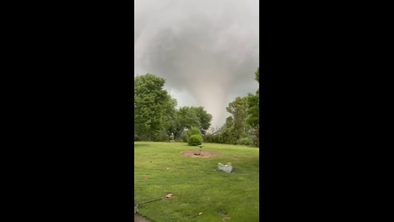
Massive tornado spotted in LaSalle County
A massive tornado was spotted in LaSalle County on Thursday evening as severe weather passed through the Chicago area.
- 6:30 p.m. — Severe Thunderstorm Warning issued for Will County until 7:30 p.m.
- 6:15 p.m. — Severe Thunderstorm Warning issued for Grundy County until 6:45 p.m.
- 6:10 p.m. — Tornado Warning issued for Kankakee County until 6:45 p.m., NWS says. A Severe Thunderstorm Warning has been issued for Lake County (IL), McHenry, and Kane Counties until 7:15 p.m.
- 6 p.m. — Tornado Warning issued for Grundy County until 7 p.m., NWS says.
- 5:45 p.m. — Severe Thunderstorm Warning issued for DeKalb and McHenry counties until 6:30 p.m. Two areas of concern is the tornado and destructive wind threat that is increasing over portions of the area, near the Ottawa to Joliet to S. Chicago line, according to the NWS.
- 5:15 p.m. — Tornado Warning for LaSalle County and Livingston County until 6:15 p.m., according to the National Weather Service. The severe thunderstorm warning for LaSalle County will expire at 5:45 p.m. and contain wind gusts up to 70 mph and tennis ball-sized hail, the NWS said.
- 3:30 p.m. — The National Weather Service reported that "Strong non-thunderstorm ‘wake low’ winds have developed behind the first round of thunderstorms. A period of wind gusts of 45-60 mph will be possible over portions of Chicago metro, including Chicago for the next 1-2 hours."
- 2:42 p.m. — A Severe Thunderstorm Warning was issued for Valparaiso, Indiana, Lake of the Four Seasons, Indiana and DeMotte, Indiana.
- 2:12 p.m. — A Severe Thunderstorm Warning went into effect for Kankakee, Crown Point, Indiana and Bourbonnais until 3:15 p.m.
- 1:55 p.m. — A Tornado Watch was issued for parts of Illinois, Indiana, Iowa, Missouri and Wisconsin until 9 p.m. The entire Chicago-area is listed under that watch.
The Source: The information in this report came from the National Weather Service and Fox Chicago Meteorologists Kaitlin Cody and JD Rudd.