

Severe weather season is stretching out

Severe weather season is stretching out
Seems like the severe weather season is expanding. That is becoming more clear from our country's perspective but more complicated from a more local view.
Seems like the severe weather season is expanding. That is becoming more clear from our country's perspective but more complicated from a more local view.
To be a severe storm it has to either produce a tornado, winds of 58 mph or stronger, and hail 1 inch in diameter or wider. The ingredients necessary to produce severe weather arrive earlier in the year and stick around later due to climate change.
Historically, the months of April, May and June are the prime months for tornado activity for the United States. More and more tornadoes are developing outside that climatologically favored window according to a recent report from Climate Central. The average number of winter (December through February) tornadoes has increased by 71%. There has been an increase of 36% during the month of March and 67% during the month of April, the first two months of meteorological spring.
A supercell is a thunderstorm with a rotating updraft that produces most significant tornadoes (EF2 or stronger) in our country. Almost all fatal tornadoes are spawned by supercells.
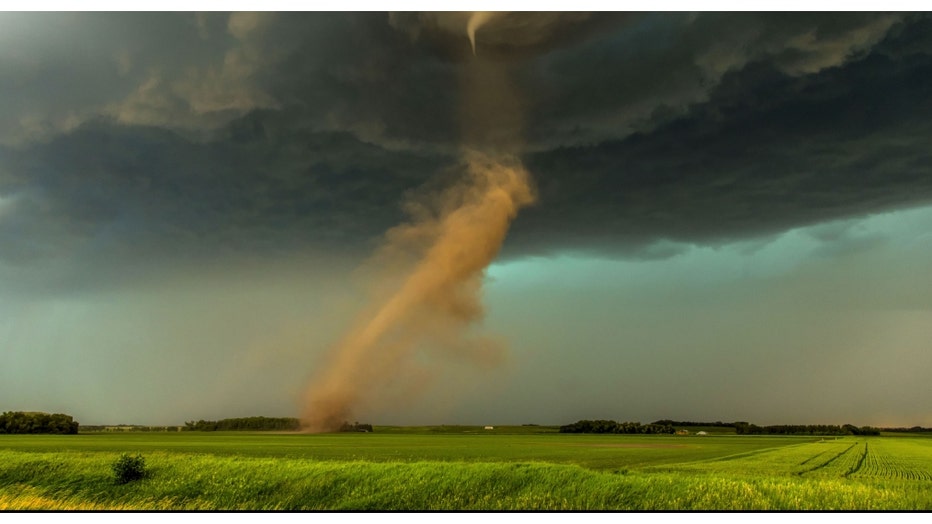
Image credit: NOAA NWS, Amanda L. Hill
SUBSCRIBE TO FOX 32 ON YOUTUBE
A new study predicts future warming of our planet from climate change will spin up more supercells outside the historical "tornado season". That means more supercells forming in February and March by the end of this century. The study also suggests more of these intense storms in April, the first month of spring.
Almost half of all the U.S. billion-dollar weather disasters that have occurred since 1980 are the result of severe storms. Severe storms account for nearly half of all U.S. billion-dollar weather disasters since 1980.
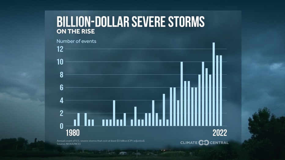
There have been six times more billion-dollar severe storms during the period from 2001 through 2022 compared to the two prior decades. A warmer world means an increase in the number of days that hold the ingredients necessary to form these storms.
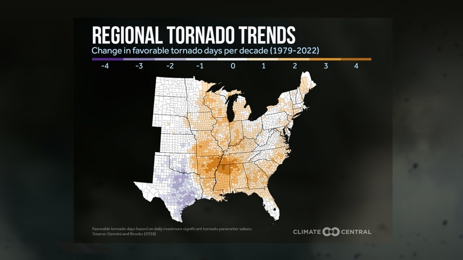
Climate change is not only expanding the country's severe weather season it may also be shifting traditional "tornado alley" eastward into more vulnerable areas. Tornado outbreaks are occurring with more frequency in the Mid-South and Southeast where there is a larger density of mobile homes. There has been an increase in the number of favorable tornado days per decade (1979-2022) in these regions which includes the state of Illinois.
Any Severe Weather Type (Tornado, Damaging Wind, and/or Damaging Hail)
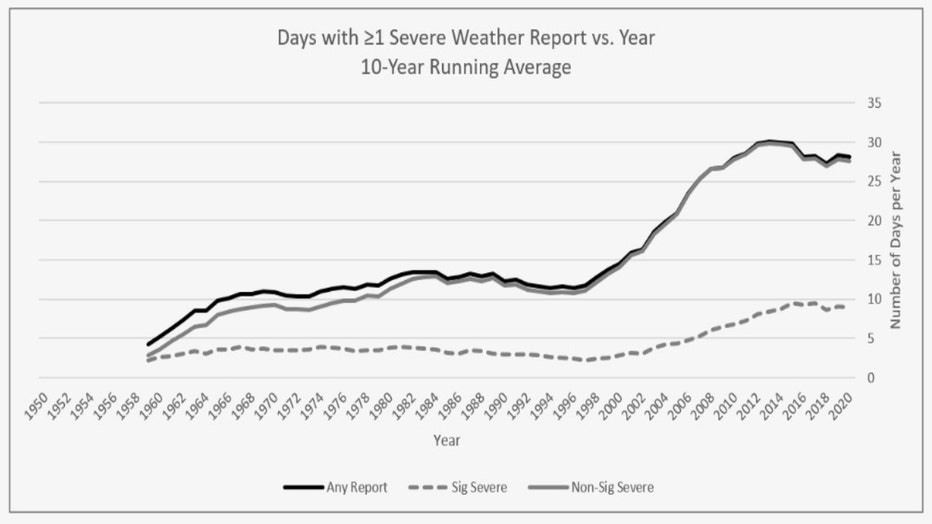
At first glance, it seems like Illinois has seen a big jump in severe storms over the past twenty years or so. The "forecast area" for the Chicago office of the National Weather Service sees around 25 to 30 days of severe weather on average. That is a large increase compared to the decades of the 60s through the 90s. Here are some of the conclusions drawn from a National Weather Service study about what could be behind this trend:
- The rise of the internet, social media, and mobile phone usage to provide the ability to report severe weather to the NWS through the early 2000s.
- A gradual increase in population in the Rockford and Chicago areas translated to more people reporting severe weather.
- An increase in "Storm Spotter" training and other education by the NWS.
- The number of days with at least one tornado as well as significantly damaging winds or hail have remained relatively constant, suggesting the apparent rise in the reports of damaging winds and hail are largely driven by Non-Significant severe weather.
- While it is possible the frequency of reported severe weather has indeed increased from the 1990s to 2000s, it is more likely factors listed above are actually most responsible.
Even still, there are some surprising severe weather stats that emerge when looking back through recent years. The list of the top ten days in Illinois with the most tornado reports in a single day includes 23 different dates since there were days that actually tied. For example, both August 10th, 2022, and June 22nd, 2016 had 15 reports of tornadoes. Those dates tied as the second-worst date for the total number of tornado reports. The list spans the years from 1950 to 2020. It is worth noting that 15 of the 23 dates on the list were from the year 2000 or later.
Some other noteworthy local severe storm stats include:
- The outbreak of tornadoes on March 31, 2023 was the 3rd largest tornado outbreak on record in the country and produced 22 tornadoes in the Chicago area.
- On February 27, 2023, rare February tornadoes in northern and central Illinois. These were the first February tornadoes to occur since February 28, 2017.
- With a tornado being confirmed in Naperville, 2023 is now the third consecutive calendar year that a tornado had occurred within the city limits of Naperville.
- The top ten list of days with the most reports of damaging hail includes 19 different dates. 18 of those 19 days occurred in the year 2000 or later.
- Every date on the list of the top ten days with the most reports of damaging winds is from the year 2007 or later.
- There was an outbreak of nine tornadoes in central Illinois on January 3rd of this year.
- There have been 91 preliminary reports of tornadoes so far in Illinois. That is nearly double what we average in an entire year. Illinois leads the country in reports of tornadoes so far this year (as of the morning of May 9th).