

Chicago weather: 70-degree high possible ahead of spring storms
CHICAGO - Today was absolutely spectacular with plenty of sunshine and highs around 60°. Weather during this time of year can be wildly different.
Take, for example, March 8 in 1931 when we were at the tail end of a two-day snowstorm that deposited 16.2 inches. This still ranks as the seventh-biggest snowstorm in Chicago history. In fact, for 36 years, it was the second-biggest snowfall on record.
Enough about my high school years. Let’s get on with the rest of the forecast.
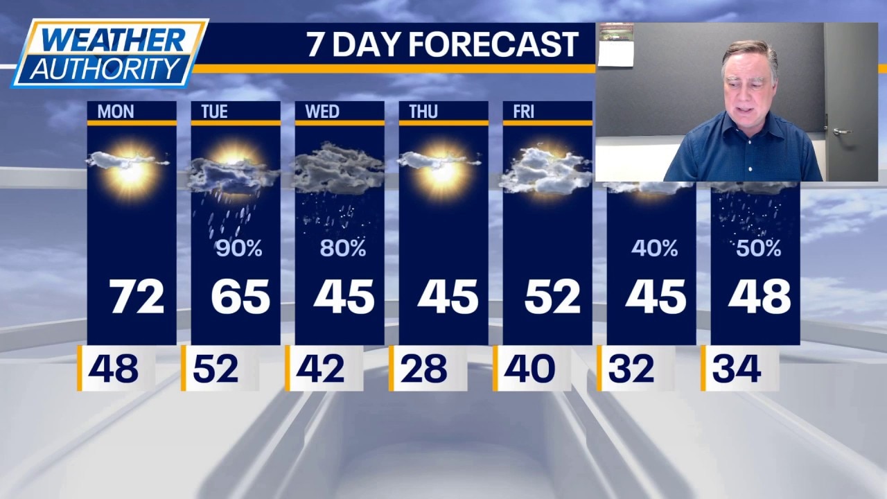
Tonight will be clear and pleasant with lows in the 40s. Tomorrow could be a record breaker. While parts of Chicagoland saw 70°+ readings on Friday, officially at O’Hare, we have yet to hit 70° this year.
That is likely to change on Monday. We will likely reach 70, breaking the standing record of 69° set only five years ago. There will be plenty of sunshine and a southwest wind driving that warmth all the way to the lakefront.
All good things must come to an end and that appears to be the case on Tuesday. A strong spring storm system will be plowing through the Midwest, and it presents a risk of severe weather over our area, especially late Tuesday afternoon and at night.
Current indications are that central Illinois and the far-southern portion of our viewing area would be at a greater risk of damaging storms, but we will be "WEATHER READY" just in case the storms come farther north.
Highs on Tuesday will exhibit a great range from north to south in our viewing area. That will have an impact on the intensity of the storms. Far north may only be in the 50s, while 70s are found in our southern counties.
After the storms exit Tuesday night, there will be some additional shower activity on Wednesday and hard as it may be to believe, some of those showers could change over to wet snow late in the day as colder air drills in. Accumulating snow is not likely.
The rest of the week turns cooler and generally dry with highs in the 40s, perhaps 50+ on Friday.