Severe weather risk ramps up for Chicago
Chicago - The atmosphere over the middle of the country will be rather unstable both Tuesday and Wednesday as a combination of factors come together to set up a scenario for severe weather.
A deepening low pressure system will pull out of the Rockies today and spin up towards northern Minnesota tomorrow.
A strong cold front will trail south from the center of this storm and sweep through the Chicago area Wednesday afternoon. Wind shear with strong, shifting winds aloft could contribute to the formation of tornadoes.
DOWNLOAD THE FOX 32 WEATHER APP
Our severe weather risk ramps up from "marginal" for some of our western suburbs today to "slight" for most of us tomorrow and even "enhanced" well south of the city and in northern Indiana.
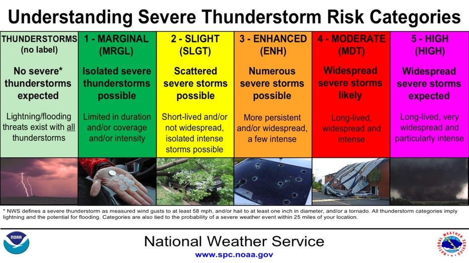
Marginal risk is category one out of five risk categories and means isolated severe storms are possible. Slight risk is category two out of five and means scattered severe storms possible.
Enhanced risk is category three out of five and means numerous severe storms are possible. All varieties of severe weather are possible from damaging winds, large hail to even tornadoes.
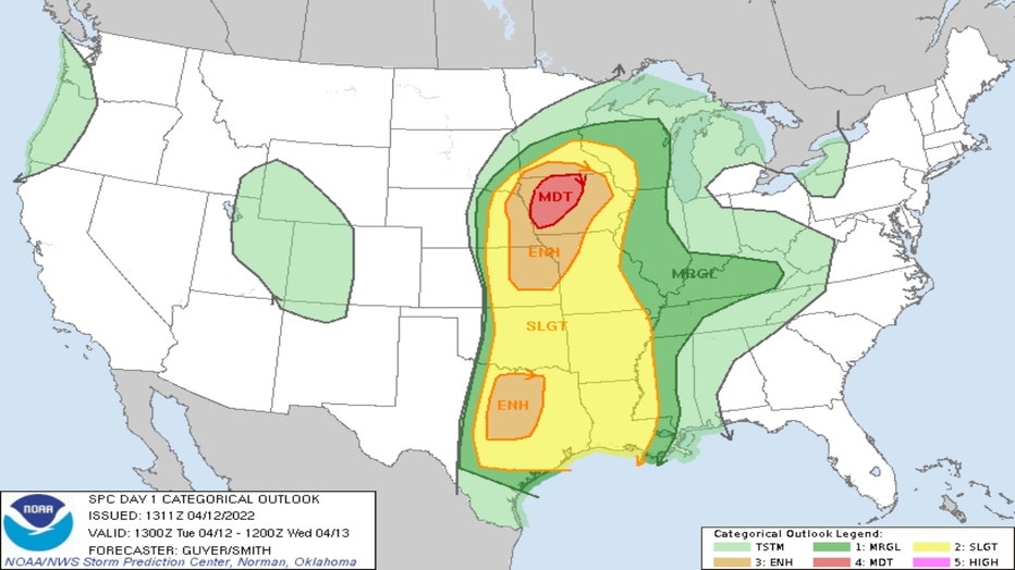
Convective Outlook For Tuesday/Tuesday Night
Today's greatest threat of severe weather is over Iowa. If severe storms formed here in the Chicago area, they would most like occur late tonight into early tomorrow morning.
The hope is that these storms would be decaying and diminishing in intensity as they move eastward out of Iowa and eventually into Illinois.
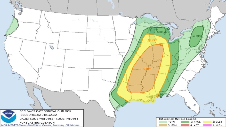
Convective Outlook For Wednesday/Wednesday Night
The window for severe storms to impact us here on Wednesday is tough to call since this is an evolving storm.
Models aren't in complete agreement on the timing of a cold front that will lift warmer, more moist and unstable air vertically to help fire up strong storms.
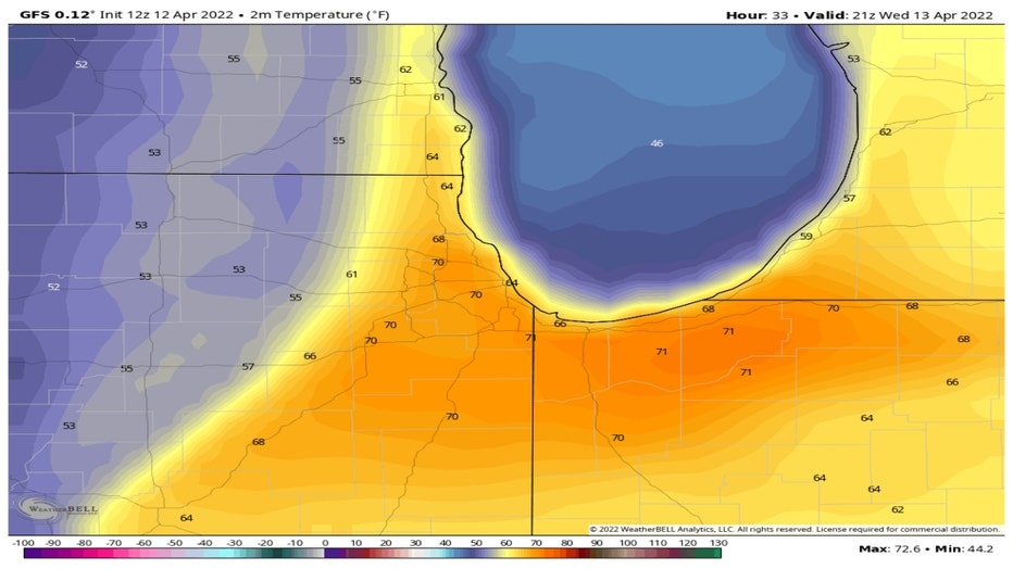
The GFS model has the front pushing into our western suburbs around 4 pm Wednesday. Notice the 70 degree readings ahead of the front in the warm sector of the storm and the 50s just behind it.
If we wake up to lingering showers and thunderstorms tomorrow morning, they could actually diminish the surface heating that would otherwise help fuel strong storms later in the day.
In other words, we need to stay tuned and be vigilant Wednesday since there are some uncertainties with this forecast.
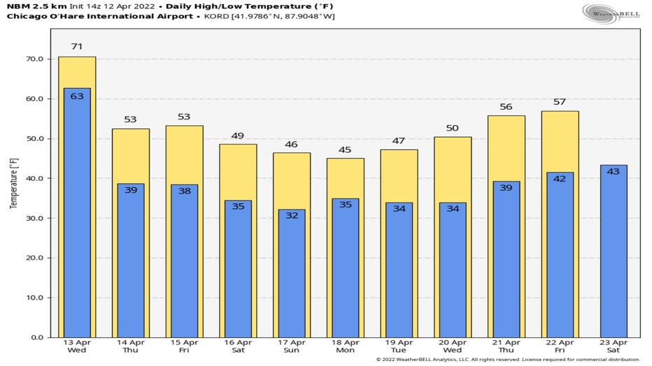
One thing is for sure. We will see a dramatic drop in temperatures beginning late tomorrow. According to the National Blend Of Models our highs will fall into the lower 50s for Thursday and Friday. Our highs fall further by the weekend when we may not climb above the 40s.