

Some sticking spring snow for the Chicago area?

Chicago weather: Some sticking spring snow could be headed our way
Chicago may not be done with sticking snow. A wintry start to the weekend could be coming.
CHICAGO - Just when you thought it was safe to put the snow shovel away…
We have been lulled into a false sense of security with today being the third straight day with highs hitting the 50s. A storm system that will nudge north out of the southern plains into the Midwest late this week could lay down a swatch of significant snow.
Still too many variables and too far out to make accurate predictions about snowfall amounts, but it looks like this storm has the potential to produce some shovelable snow wherever it targets.
We may be due for some snow since we are well below average for the month of March and for our snow season. We have seen 1.8 inches of snow so far this month which is 2.7 inches below average. We have picked up 19.7 inches since the start of fall which is 16.4 inches below average. That means we have only seen about 55% of average snowfall since Oct. 1.
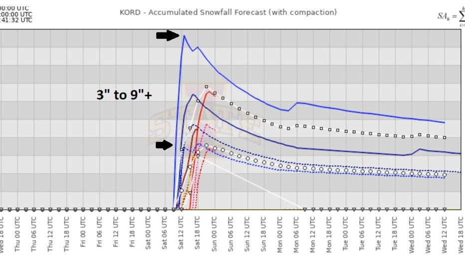
Accumlated snowfall meteogram for O'Hare
A meteogram is a way to display several computer model forecasts at once for easy comparison. The wider the range of solutions, the less the consensus among models and the greater the uncertainty to the forecast.
The accumulated snowfall meteogram for O'Hare above shows a range of snowfall for early Saturday from as little as 3 inches to as much as nearly 10 inches. The takeaway here is that there is the potential for an impactful spring snow this weekend. We shouldn't focus on the numbers yet.
SUBSCRIBE TO FOX 32 ON YOUTUBE
Just take this as a heads up to be prepared for some snow that may stick. It would be heavy wet snow since this system will not be working with very cold air.
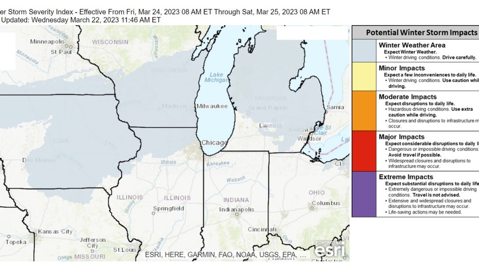
Winter Severity Storm Index for Friday night into Saturday morning
The National Weather Service's Winter Storm Severity Index, or WSSI, helps to outline areas of the country that will be impacted by potential winter storms and give us an idea of the type of impacts that could be coming.
Saturday is about as far out as the WSSI goes at this point but a good portion of northern Illinois is in the "winter weather area" which is the lowest end of the impact scale for now. This will be refined as we get closer to the event.
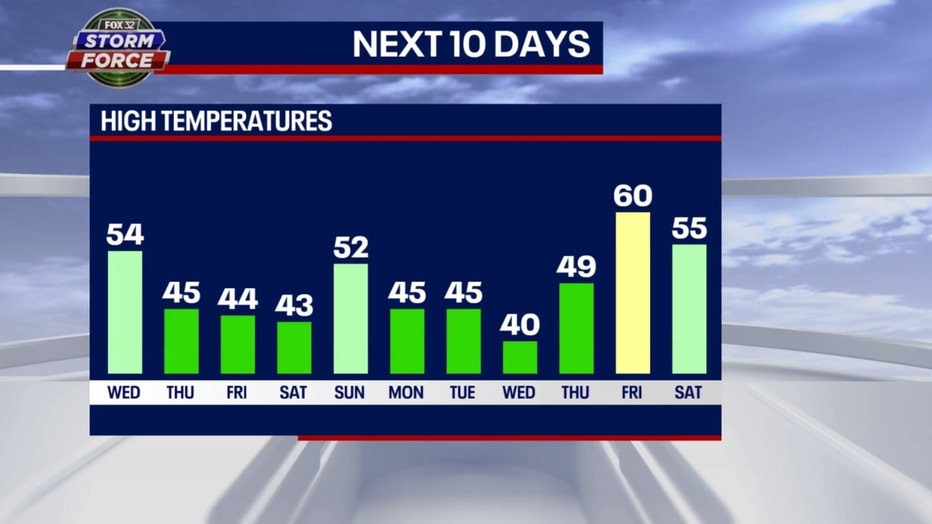
Our Fox model has that typical rollercoaster ride look to it that we see so often in spring. 50s for highs today then back below average through Saturday before 50s return Sunday. Colder than average early next week is followed by a warm-up with highs hitting 60 possibly a week from Friday. That means seven of the next ten days would be below average if this forecast verifies.
The Climate Prediction Center's long-range temperature keeps a colder than average forecast coming overall through the start of April.
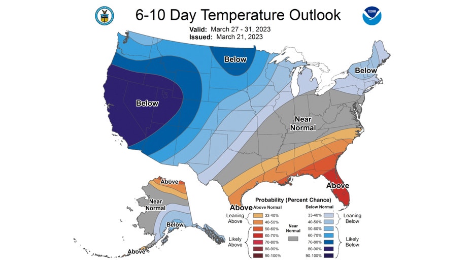
The 6-10 day temperature outlook has us "leaning below" average overall from next Monday through the following Friday.
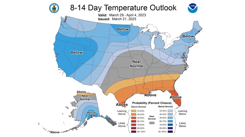
The 8-14 day temperature outlook has us "leaning below" average overall. This covers the period from next Wednesday through the following Tuesday and into the start of April.