

Tropical Storm Ian forecast to rapidly intensify into hurricane today, significant threat eyes Florida
While Ian has been slow to organize, the FOX Forecast Center expects the storm to gain strength in the Caribbean Sea, and much of Florida is included in the forecast cone for what will likely become a major hurricane in the coming days.
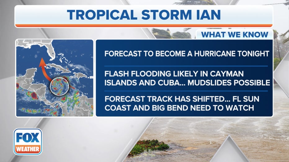
The National Hurricane Center issued a Tropical Storm Warning for the lower Florida Keys as Tropical Storm Ian moves closer to the U.S. It is forecast to become a hurricane Monday.
Florida Gov. Ron DeSantis urged Floridians to take precautions and declared a state of emergency for all 67 counties ahead of the impacts of Tropical Storm Ian, which is expected to undergo a period of rapid intensification on Sunday and Monday.

The projected path and intensity of Tropical Storm Ian. (FOX Weather)
Rapid intensification occurs when a tropical cyclone's (tropical depression, tropical storm or hurricane) maximum sustained winds increase by at least 35 mph in a 24-hour period, according to the National Hurricane Center.
"Make preparations now," DeSantis said at a news conference on Sunday. "I know a lot of people have been doing it throughout the state of Florida."
"I'm really concerned that people won’t take the threat seriously, especially for places like Tampa Naples and Fort Myers. They are looking at the cone or the track and it looks like its offshore or west of the and they are probably downplaying the impact," Acting Director the NHC, Jamie Rhone told FOX Weather. "But what I want to stress to those people is that it really doesn't take a ton of wind in this part of the country to push water onto the coast. And we could be looking at a decent storm surge event even if the track is offshore.
HOW TO WATCH FOX WEATHER ON TV
Ian's forecast has trended westward over the weekend. So while there continues to be some uncertainty, which is typical this far out in time, here's everything the FOX Forecast Center knows about this significant hurricane threat to the southeastern U.S. later this week.
Tracking Tropical Storm Ian. (FOX Weather)
Where is Tropical Storm Ian?
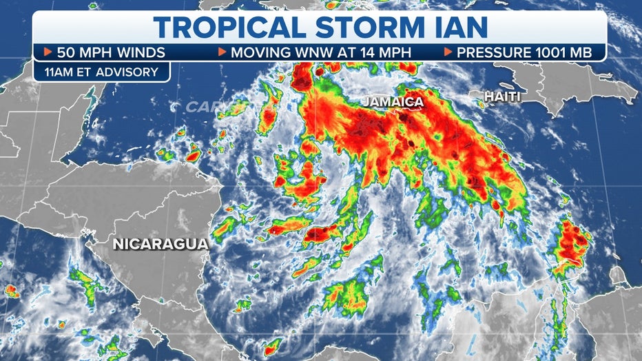
As of Sunday evening, Tropical Storm Ian was in the Caribbean Sea and centered about 160 miles south of Grand Cayman in the Cayman Islands and more than 430 miles away from the western tip of Cuba.
Ian had maximum sustained winds of about 60 mph and was moving northwest at 12 mph.
"You see while it doesn’t have an eye, you can see a very impressive twist, rotation in the clouds so that implies a lot of structure there," Rhone said. "So when it moves into a more conducive environment, especially the northwest Caribbean where the oceans are very warm, it could rapidly intensify and all our guidance is showing that’s a high probability."
Current watches and warnings in effect for Tropical Storm Ian. (FOX Weather)
Tropical Storm Ian's outer bands were producing showers with locally heavy rain that was spreading into parts of Jamaica.
The Hurricane Hunters have several missions scheduled for Tropical Storm Ian to collect data that will be used to help meteorologists refine their forecasts.
KNOW YOUR ZONE: FLORIDA EVACUATION MAP SHOWS WHO WILL HAVE TO LEAVE BEFORE A HURRICANE STRIKES
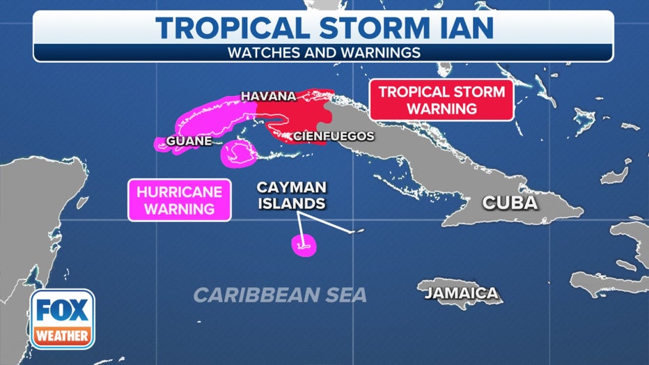
Where are watches and warnings in effect?
A Hurricane Warning has been issued for Grand Cayman in the Cayman Islands and the Cuban provinces of Isla de Juventud, Pinar del Rio and Artemisa. The NHC track expects Ian to pass near the Cayman Islands on Monday. Monday night and early Tuesday, it could pass over or very near western Cuba before entering the Gulf of Mexico Tuesday.

Fox 13 Meteorologist Tony Sadiku is watching Tropical Storm Ian closely. As of Sunday morning, Tropical Storm Ian had top winds of 50 miles per hour and was moving west-northwest at 12 miles per hour. Ian is expected to intensify rapidly and Sadiku says it could become a category 1 hurricane by late Sunday night or early Monday morning. According to Sadiku, the entire west coast of Florida is fair game for a hurricane landfall next week. He advises residents to get prepared now, so those plans can be implemented when there is a better idea of where the storm will hit.
A Hurricane Warning means that winds of at least 74 mph are expected within the warning area. A warning is typically issued 36 hours before the anticipated first occurrence of tropical storm-force winds (39-plus mph), conditions that make preparations difficult or dangerous.
A Tropical Storm Warning is in effect for the Cuban provinces of La Habana, Mayabeque and Mantanzas.
A Tropical Storm Warning means that winds of at least 39 mph are expected within the warning area within 36 hours.
Here's what we know about Tropical Storm Ian. (FOX Weather)
A Tropical Storm Watch is in effect for the lower Florida Keys from Seven Mile Bridge to Key West. Little Cayman and Cayman Brac along with the Dry Tortugas are also in the watch.
A Tropical Storm Watch means tropical-storm-force winds (sustained winds of 39 to 73 mph) are possible within the storm watch area, generally within 48 hours.
WHAT TO DO WHEN HURRICANE OR TROPICAL STORM WATCHES AND WARNINGS ARE ISSUED FOR YOUR TOWN
What is the forecast for Tropical Storm Ian?
Rapid intensification of Tropical Storm Ian is forecast to begin Monday.
The latest forecast from the National Hurricane Center shows Ian becoming a hurricane Monday, then reaching major-hurricane strength (Category 3 or stronger) Tuesday.
Ian will move into an area containing an abundant supply of deep, warm waters. (FOX Weather)
"We are confident that the track is going to move over Cuba, but once it slowly starts to drift over to the Sunshine State, that is where the models, the spread is growing with continued intensity," FOX Weather meteorologist Jason Frazer said. "Now, we are very confident that this is going to be a hurricane by the time it impacts the United States. But, could it impact those of you in Tampa? Could it impact those of you in Tallahassee? That is what we keep going back and forth with over here."
HOW ARE HURRICANES RATED? THE SAFFIR-SIMPSON HURRICANE WIND SCALE EXPLAINED
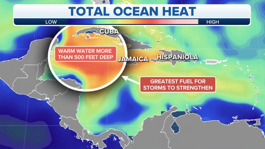
The combination of deep, warm waters and relaxed wind shear – winds that change direction and speed at various heights – over the Caribbean Sea is expected to allow Ian to rapidly intensify into a major hurricane.
"There's a lot of fuel in the Gulf of Mexico. The average temperature is about 87 degrees, and the maximum water temperature is about 89 degrees," Frazer said. "That is just fuel for these hurricanes. Hurricanes love temperatures that are in excess of 80 degrees and low wind shear. And there is no wind shear happening right now in the Gulf of Mexico."
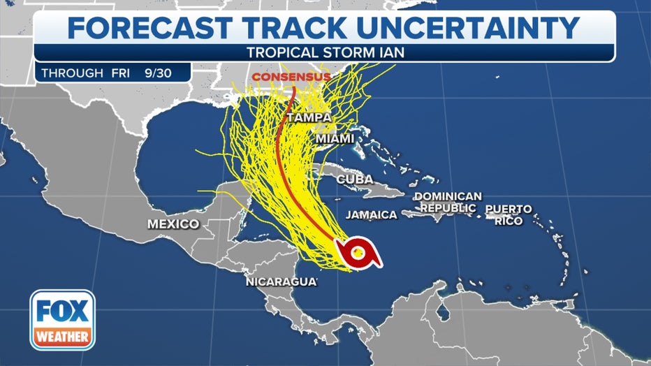
Each yellow line on the map depicts a different computer forecast model solution.(FOX Weather)
The Loop Current, a current of very warm water flowing northward from the western Caribbean Sea into the southern Gulf of Mexico, could also provide a boost to Ian's intensification rate, as it has long been known to be a significant source of fuel for strong Gulf of Mexico hurricanes.
Later this week, wind shear is expected to increase as Ian heads northward through the Gulf of Mexico, and that will likely cause the future hurricane to weaken in intensity as it approaches the northern or eastern Gulf Coast toward the end of the workweek.
But Ian is forecast to be a large hurricane regardless of its intensity, and its forward progress is expected to slow down, so Ian will still be a significant hurricane threat along the northern or eastern Gulf Coast regardless of its category rating on the Saffir-Simpson Hurricane Wind Scale.
What are the expected impacts of Tropical Storm Ian in the Caribbean?
Hurricane-force winds (74-plus mph) are expected to reach Grand Cayman in the Cayman Islands Monday, with tropical-storm-force winds (39-plus mph) expected there for Tuesday.
Tropical-storm-force winds are expected in the Tropical Storm Warning areas of Cuba by early Tuesday.
Additionally, 3 to 6 inches of rain is predicted across Jamaica and the Cayman Islands, with isolated amounts up to 8 inches possible.
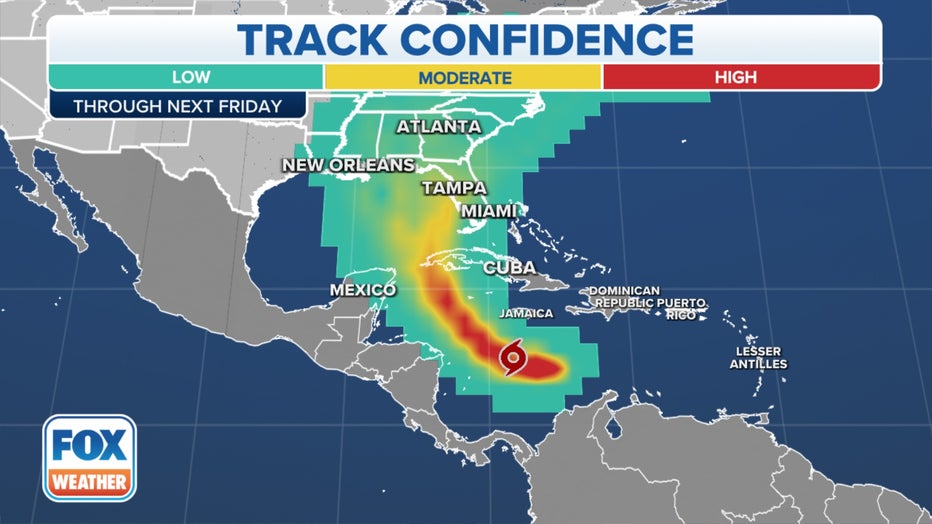
The various colors on the map indicate the confidence level in the track of Ian. (FOX Weather)
Even higher rainfall totals are forecast for western Cuba, where 6 to 10 inches is expected, with localized totals up to 16 inches possible.
The heavy rain could produce flash flooding and mudslides in hilly and mountainous areas, particularly in Jamaica and Cuba.
The NHC reports that storm surge could swell seas 9 to 14 feet over normal tides in western Cuba and 2 to 4 feet above normal tides in the Cayman Islands.
The Florida Keys into south and central Florida could see 2 to 4 inches of rain, up to 6 inches locally between Monday and Wednesday.
North Florida and the Panhandle could see rain Thursday through Saturday.
HERE ARE THE BUZZWORDS YOU'LL BE HEARING DURING HURRICANE SEASON
What threat will Tropical Storm Ian pose to Florida and the US Gulf Coast?
Tropical Storm Ian is predicted to be steered northward into the eastern Gulf of Mexico Tuesday.
However, the range in possible tracks from the computer forecast models indicates Ian could track anywhere from the Florida Panhandle to portions of the Florida Peninsula.
Florida Gov. Ron DeSantis warned in a Sunday press conference of likely power outages once Tropical Storm Ian moves closer to Florida.
"Anticipate, particularly the closer you are to where the eye of the storm makes landfall, anticipate power outages. That is something that will likely happen with a hurricane of this magnitude."
Each yellow line on the map below depicts a different computer forecast model solution.
National Weather Service offices around the country are launching extra weather balloons each day to provide additional data for the computer forecast models that will be used to help meteorologists refine their forecasts.
The expected increase in size of Ian and its potential to slow down in forward progress near the Gulf Coast will increase the threat of life-threatening storm surge, regardless of the future hurricane's intensity at landfall.
But prior to any landfall in Florida or along the northern or eastern Gulf Coast, locally heavy rain will begin to spread into the Florida Keys and Central and South Florida beginning Monday and persisting through Wednesday morning. Between 2 and 4 inches of rain is expected, with isolated amounts up to 6 inches possible.
Locally heavy rain could then spread toward North Florida, the Florida Panhandle and the southeastern U.S. on Thursday, Friday and Saturday.
This heavy rain may result in flash and urban flooding across the Florida Keys and the Florida Peninsula through midweek. Additional flooding and rises on area streams and rivers across North Florida and parts of the southeastern U.S. later this week can't be ruled out, especially in Central Florida given already-saturated conditions.
HOW TO PREPARE FOR A HURRICANE
Beyond Ian's expected impact on Florida or the northern or eastern Gulf Coast, it will then either move inland somewhere over the southeastern U.S., or it could track near or along portions of the Eastern Seaboard.
So the bottom line is that it's still too early to know exactly where Tropical Storm Ian will track after its landfall, but know that there could be threats of wind and flooding rainfall extending into other parts of the southeastern and eastern U.S. late this week and into next weekend.
Florida's emergency management agency is advising residents to prepare for the coming storm now. Floridians can check their evacuation zone by typing their address into an interactive map.
The FOX Forecast Center will be keeping a close eye on this system as it strengthens and tracks across the Caribbean and eastern Gulf of Mexico in the days ahead.