

Winter storm could bring significant snowfall to Chicago area this week

Early morning forecast for Chicagoland on Feb. 24th
FOX 32's Mike Caplan takes a look at today's weather.
CHICAGO - Computer models are not set just yet, but it is possible the Chicago area could get hit with more than a foot of snow this week.
FOX 32 meteorologist Mike Caplan has been discussing the snow event on his Facebook page, which would hit our area Monday night through Wednesday – making it a more than 40-hour storm.
“the brand new run of the NAM computer model (just in) shows a MONSTER snowstorm here. This is still subject to change and perhaps significantly so. I’ll point out that this model only goes out to noon on Wednesday. There would be many more hours of snow left ON TOP of the numbers shown here. I share this simply to alert you to the POSSIBILITY of disruptive snowfall perhaps for more than 48 hours starting Monday night. This is still “out there” and the forecast numbers are going to change. How much remains to be seen,” Caplan posted on Facebook Saturday night.
The following two graphics are the NAM computer models from Saturday night and Sunday morning, showing as much as 14 to 15 inches of snow falling in parts of our area.
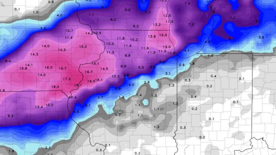
NAM computer model from Saturday night.
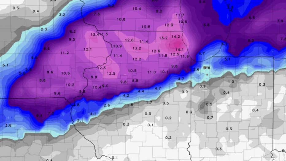
The most recent NAM computer model as of Sunday morning.
Shortly after that post, Caplan issued an update.
“And now the latest model info just in. And it is vastly different, wouldn’t you agree? This is the GFS which remains the northern-most model, punishing Wisconsin with a major snowstorm and barely bringing a flake to the city of Chicago. The one thing that IS consistent is that a significant winter storm is on the way Monday night-Wednesday night. The question remains exactly where that axis of huge snowfall will occur. To be continued...”
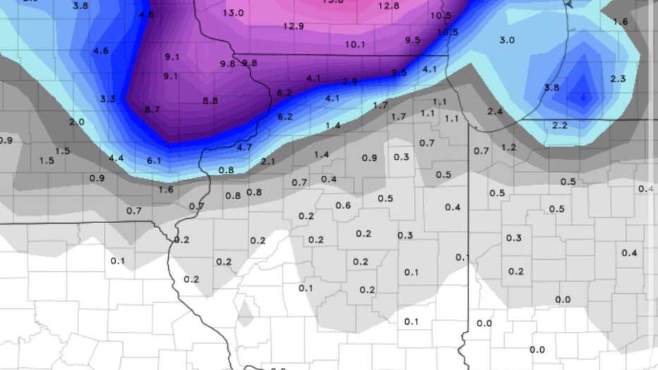
The following two graphics are the GFS computer models from Saturday night and Sunday morning, showing anywhere from a flake to 7 inches of snow falling in parts of our area.
GFS computer model from Saturday night.
The most recent GFS model as of Sunday morning.
Early Sunday morning, Caplan discussed snow totals based off the European computer model.
“Here’s the euro. Bear in mind these numbers are at a 10:1 ratio of snow to liquid. The totals would be somewhat higher than what are shown.”
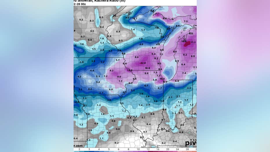
The following two graphics are the EURO models from Saturday night and Sunday afternoon, showing 8 to 11 inches of snow falling in parts of our area.

The EURO model from Saturday night.

The most recent EURO model as of Sunday afternoon.
"The new European model. Significant snowfall still very much in play Tuesday-Wednesday," Caplan posted on Facebook Sunday afternoon.
And the following is the GDPS (Canadian) computer model from Sunday morning, showing as much as 10 inches of snow falling in parts of our area.
The most recent GDPS (Canadian) computer model as of Sunday morning.
One thing is for sure: the warm weekend we experienced will be coming to a swift end come Monday.
“Have fun in the sun today because it all goes back to winter starting tomorrow night through Wednesday. Big numbers continue to come in and I’m not talking about temperatures. Rely on this [Facebook] page for realistic assessments of the storm potential and timely updates during the days to come,” Caplan posted Sunday morning. He will be providing an update on his Facebook page around 7 p.m. Sunday night.
Since the meteorological winter started on December 1, 2019, the Chicago area has receieved 16.9 inches of snow, which is 9.5 inches below normal. Usually at this time of the season -- going by the average -- we should be sitting at 26.4 inches of snow that has fallen, Caplan says.
This February alone, our area has receieved 7.1 inches of snow. According to the average, the month of February usually sees 9.1 inches of snowfall, FOX 32 chief meteorologist Bill Bellis reported on Twitter.

Stay tuned for updates on this potential snowstorm. Get FOX 32 News on the go by clicking here!