

NASA photos may show evidence of ancient wild river on Mars

Mars rover Curiosity celebrates 10 years
Mars rover Curiosity has been exploring the Red Planet for a decade (Credit: NASA)
The dry, red planet may have once been home to a powerful river, a discovery that could help scientists in their efforts to find signs of ancient microbial life on Mars, according to NASA.
Photos released on Tuesday show signs of a large river that flowed into the Jezero Crater, a 28-mile-wide area that lies just north of the equator on Mars. The river was part of a network of waterways flowing into the crater, NASA said.
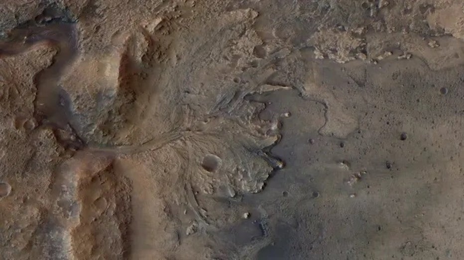
FILE - This satellite image shows the remains of an ancient river delta in the Jezero Crater on Mars. (ESA / DLR / FU-Berlin / NASA)
The images were taken by NASA’s Perseverance rover, which has been exploring the Jezero Crater for two years. The images were then stitched together to create two mosaics that provided a close-up look at curved bands of layered rock that had only been seen from space.
SEE THE RED PLANET IN VIVID DETAIL WITH NEW INTERACTIVE NASA IMAGERY
One of the mosaics of this curvilinear unit allowed scientists to inspect a portion known as "Skrinkle Haven." Skrinkle Haven is composed of curved rock layers that scientists believe were formed by powerfully flowing water.
According to NASA, the layers of Skrinkle Haven could either be the remnants of a river’s banks that shifted over time or remnants of sandbars, or small islands that formed in the river.
The question now is whether that ancient waterway was more akin to the Mississippi River, which winds snakelike across the landscape, or the Platte River in Nebraska, a sprawling, braided river that forms sandbars.
The second mosaic of images shows another portion of the curvilinear unit. Called "Pinestand," the feature is an isolated hill with sedimentary layers that curve upward as high as 66 feet, according to NASA.
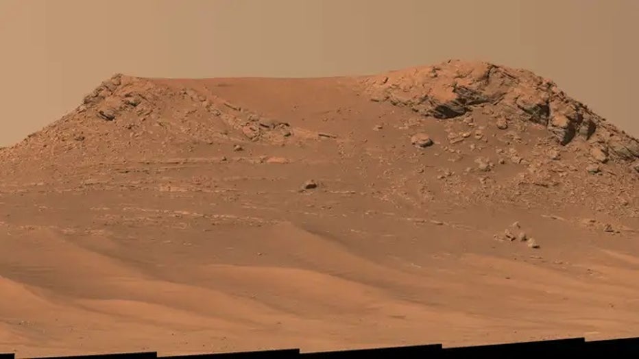
NASA’s Perseverance Mars rover captured this mosaic of an isolated hill nicknamed "Pinestand." (NASA / JPL-Caltech / ASU / MSSS / NASA)
Scientists believe the layers may have also been formed by a powerful river, but are also exploring other possible explanations.
"What’s exciting here is we’ve entered a new phase of Jezero’s history. And it’s the first time we’re seeing environments like this on Mars," said Katie Stack Morgan of NASA's Jet Propulsion Laboratory and Perseverance’s deputy project scientist. "We’re thinking about rivers on a different scale than we have before."
Scientists will continue to study the images taken by Perseverance to better understand the Martian landscape, its ancient, watery past, and clues for microbial life that may have existed around the water source.