

A warmer and possibly wild week of weather ahead for Chicago

Chicagoland weather forecast for Sunday night, April 10
FOX 32 Chicago Meteorologist Tim McGill says we're looking at the possibility of strong storms this week.
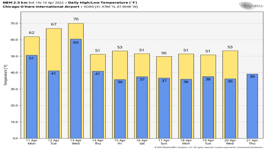
Chicago - Sunday's 60s almost made me forget about the snow that fell Friday and Saturday. Almost. The last two weeks and two days have been depressing for fans of warmer spring weather. Thirteen of the past sixteen days have been colder than average. Seven of the past sixteen days have seen at least a trace of snow or more at O'Hare.
Hang in there. We get a reprieve from chilly spring weather at least for a few days this week. We will warm up through Wednesday with highs soaring to near 70 degrees by the middle of the week. Average highs for this time of the year are in the upper 50s.
Enjoy it while you can. Temperatures then tumble with highs falling back to near 50 degrees for possible seven straight days.
The National Blend Of Models forecast for the next several days shows the rise and then fall of temperatures.
The dramatic drop in temperatures Wednesday to Thursday could in part play a role in a severe weather outbreak from the northern plains and upper Midwest to the southern plains and Gulf Coast region. A wide swath of the US could see some severe weather especially Wednesday into Thursday.
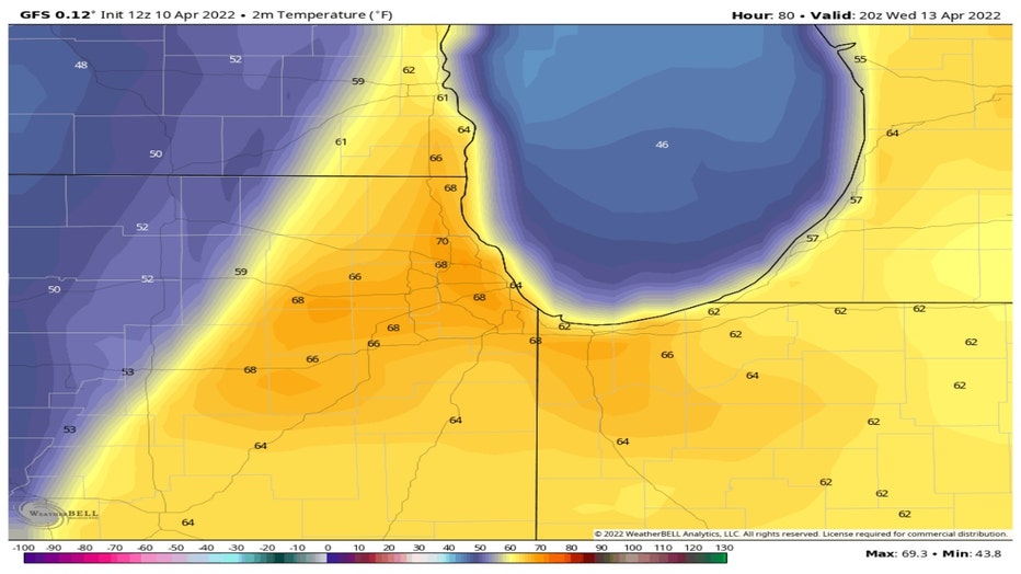
The GFS model show our highs climbing to near 70 degrees Wednesday afternoon. A strong cold front is forecast to sweep across the area late Wednesday into Wednesday night. Notice the colder 50s, represented by the blue color, pushing in from the west around 3 pm that day.
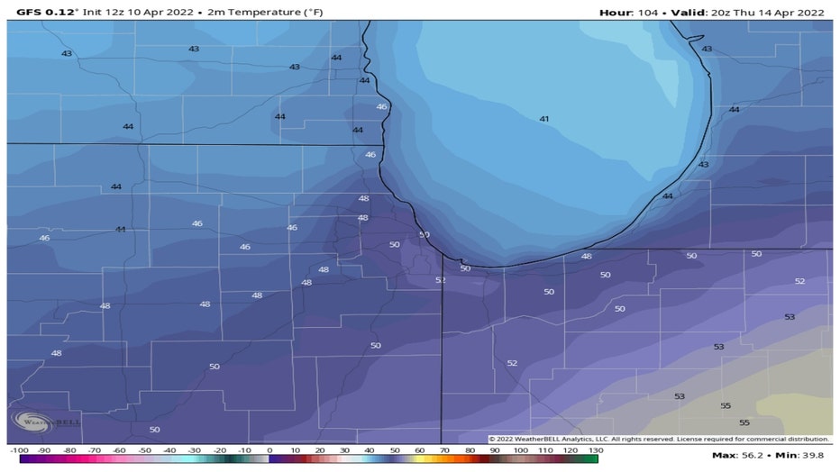
The GFS model then brings all blue in for Thursday afternoon as our highs fall to near 50 degrees. Winds may gust Thursday to near 50 mph as the colder air comes crashing in.
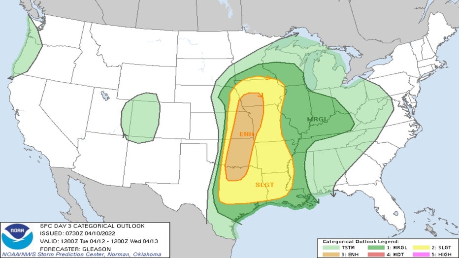
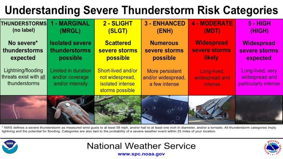
The Storm Prediction Center has placed us in a "marginal" risk for severe weather for Tuesday. The outlook covers Tuesday and Tuesday night. The best chance for these would be late Tuesday night into the early morning hours Wednesday. Higher risks of severe weather lurk just to our west from Iowa southward to Texas. There is a "slight" to "enhanced" risk of severe weather for this area. Our marginal risk means more isolated severe storms are possible that would not last as long as storms in the areas with higher risk of severe weather. Slight risk means scattered severe storms possible while enhanced risk means numerous severe storms are possible. All varieties of severe weather are possible from damaging winds, large hail to even tornadoes.
The convective outlook for Wednesday and Wednesday night will be issued Monday. I suspect the severe weather risk will be at least marginal or even higher for late Wednesday into early Thursday morning here.
This is an evolving situation and should be monitored closely this week. The ingredients will be in place for a severe weather outbreak in the middle of the country. A deep area of low pressure at the surface over eastern Colorado will draw warmer, moist air from the Gulf of Mexico while colder air will sink south and east behind a cold front trailing south of the low. Wind shear will accompany this storm too. That means a change in wind speed, and/or wind direction with height through an atmosphere that could be rather unstable.
To round out a potentially wild week of weather there is even a chance for some wet flakes of snow to fly Saturday night into early Sunday.
Stay tuned.