

Chicago Weather: Flooding concerns after storms sweep through area
CHICAGO - A dangerous round of severe weather is expected to move through the Chicago area on Tuesday, bringing the threat of strong tornadoes, large hail and rapidly changing conditions from the afternoon into the evening.
Follow along below for live updates throughout the day as storms develop and move through the region.
Live severe weather updates
- 11:23 p.m.: From Meteorologist Emily Wahls: All Tornado Watches in NE Illinois have been cancelled. All Severe Thunderstorm Warnings have also expired. The severe threat is winding down for the night, although the flood concern will continue in areas that have seen heavy rain.
- 11:10 p.m.: From Meteorologist Emily Wahls: All counties shaded in green are in a Flood Watch due to excessive rainfall and saturated soil from previous rain. A Flash Flood Warning (teal box over N Cook & N DuPage) is in effect until 3:45 AM. Between 1 and 2 inches of rain have fallen and worsening of flood impacts is occurring or imminent.

- 11:05 p.m.: From Meteorologist Emily Wahls: Flooding is becoming a concern with heavy downpours moving through the same areas. The Tornado Watch has been cancelled in our far west and NW counties, EXCEPT Lake (IL), DuPage, Cook, and LaPorte. A Severe Thunderstorm Warning remains in effect until 11:15pm for parts of N/central Cook and NE DuPage.
- 10:50 p.m.: Flash Flood Warning issued for parts of northern Cook County until 3:45 a.m.
- 10:37 p.m.: The National Weather Service says the line of thunderstorms will continue to drift east and southeast across northern and northeast Illinois and northwest Indiana overnight. Though strong storms are possible, the severe threat appears to be lessening.
- 10:30 p.m.: Severe Thunderstorm Warning issued for Cook County, DuPage County until 11:15 p.m.
- 10 p.m.: Severe Thunderstorm Warning issued for Kane County until 10:30 p.m.
- 9:30 p.m.: Severe Thunderstorm Warning issued for Cook County and Lake County until 10:30 p.m. The storm system could bring 70 mph winds.
- 9:25 p.m.: Severe Thunderstorm Warning issued for parts of DeKalb and Kane Counties until 10 p.m. Winds reaching up to 70 mph are possible.
- 9:15 p.m.: Severe Thunderstorm Warning remains in effect in McHenry and Lake Counties with 70 mph winds. McHenry County also has a warning until 9:30 p.m. and Lake County has a warning until 9:45 p.m.
- 8:59 p.m.: Tornado Watch expanded to include Cook County and DuPage County until midnight.
- 8:50 p.m.: Severe Thunderstorm Warning issued for Lake County, IL until 9:45 p.m. According to the National Weather Service, the main threats from these storms will be damaging winds and hail, but a brief tornado is possible.
- 8:23 p.m.: Tornado Warning issued for Winnebago County until 8:45 p.m.
- 8:20 p.m.: A Severe Thunderstorm Warning has been issued for McHenry County until 9:30 p.m.
- 8 p.m.: A Tornado Watch has been issued for LaPorte County until 3 a.m. and a Severe Thunderstorm Warning issued for Winnebago County until 9 p.m.
- 7:38 p.m.: Severe storms are moving through northwest Illinois, heading toward the Chicago area. A tornado watch remains in effect and a flood watch has also been issued through 6 a.m.
- 2:30 p.m.: A Tornado Watch has been issued for Lake, McHenry, Kane and DeKalb counties until 10 p.m.
- Two rounds of severe storms are expected today, with the first bringing hail and damaging winds mainly south of I-80 this afternoon, followed by a broader second round this evening that could include all severe hazards, including tornadoes.
What to know:
Severe storms are expected to sweep across the Midwest today, with all hazards on the table, including tornadoes, destructive winds and large hail.
This comes after severe storms on Monday dropped damaging tornadoes and hail across Minnesota, Wisconsin and Kansas. An active spring weather pattern has developed across the Central U.S. with severe thunderstorms likely throughout the week.

Expected severe weather threats this week. (FOX Weather)
Tuesday tornado threat includes Milwaukee, Chicago
The severe weather threat has expanded for Tuesday. A Level 3 out of 5 severe storm risk is in effect across parts of Iowa, Wisconsin, Illinois, Indiana and Michigan, including Chicago and Milwaukee.

The Storm Prediction Center has just expanded the Level 3 of 5 severe weather threat zone for today.
A warm front will once again be re-established across this Level 3 threat area and will amplify storms that cross this boundary. These storms are expected to produce hail larger than 2 inches in diameter beginning mid-to-late afternoon.
Furthermore, conditions will be ripe for supercell thunderstorms capable of producing tornadoes EF-2 or higher along or south of the warm front.
The window for the most severe weather is between 5 p.m. and midnight. Additionally, the National Weather Service said several waves of thunderstorms and heavy showers could lead to flash flooding.
Where intense tornadoes are most likely to strike
The greatest potential for intense tornadoes today is concentrated along a corridor stretching across eastern Iowa, northern Illinois, and southern Wisconsin.

The Storm Prediction Center is concerned about the threat for intense (EF-3+) tornadoes across parts of the Midwest later today.
Any discrete supercell storms that can develop along this boundary will have the best chance of producing intense, long-track tornadoes EF-3 or higher.
If you are in the path of this expanded risk zone, now is the time to review your severe weather plan.
As the evening progresses, this threat will likely transition into a damaging wind event as storms congeal into a fast-moving line across the Great Lakes.
Record spring heat provides high-octane fuel for Midwest tornado threat
Record-breaking spring warmth is acting as high-octane storm fuel for today’s severe weather, with temperatures soaring as much as 20 to 30 degrees above average across the Midwest.

Forecast high temperatures for Tuesday across the eastern half of the United States.
This unseasonable heat is rapidly increasing atmospheric instability, or CAPE (Convective Available Potential Energy), creating a volatile environment where air can rise explosively into the upper atmosphere.
When this intense surface heat clashes with an approaching cold front and a powerful jet stream, it provides the raw energy needed to sustain long-track supercells and high-intensity tornadoes.
Wednesday: Third round of storms for Central US; potential for flash flooding
Storms are expected to shift toward the Mississippi River Valleys, with the possibility for damaging wind gusts, hail and tornadoes primarily across a corridor that includes Oklahoma, eastern Kansas, western Missouri, eastern Iowa, western Illinois and parts of southern Wisconsin.
In addition to the severe component, thunderstorms will release heavy moisture from the atmosphere, leading to downpours producing one to two inches of rain.

Flash flood threat (FOX Weather)
A Level 1 out of 4 risk of flash flooding covers that same corridor from Texas to Michigan.
Chicago forecast: What's next?
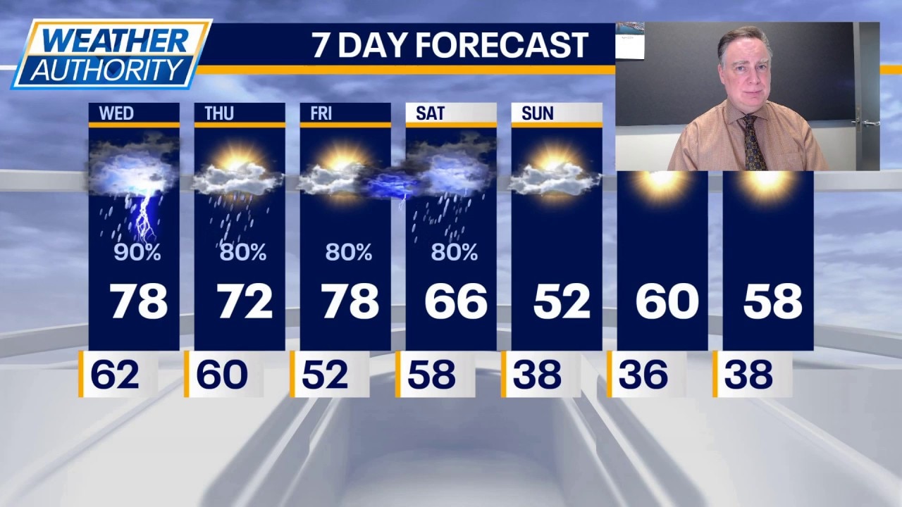
Wednesday could open with a few lingering showers in the morning and a thunderstorm is certainly possible at almost any time of day. Highs will be in the mid to upper 70s. The higher chance for a stronger thunderstorm arrives during the evening with all hazards once again in play, but perhaps not as widespread or as intense as the setup tonight.
After any early morning showers end on Thursday, there should be some quiet time for the rest of the day with highs again well into the 70s.
Severe weather threat peaks tonight with possible tornadoes, large hail
Mike Caplan has your Chicago weather update!
Friday should start dry, but the next storm system arrives late in the day and at night. It’s still several days away, but some of those storms could be severe once again, followed by a distinct cooldown over the weekend.
In fact, it’s possible Saturday night and Sunday night will have frost across much of our area away from the city. Highs on Saturday will be close to 60 but closer to 50 on Sunday with the cool weather continuing Monday.
The Source: The information in this story came from FOX Weather and FOX Chicago's Mike Caplan.