

Chicago's winter that wasn't

Chicagos winter that wasnt
You call that a winter? Aside from some tough days in January, most of this winter was mild and snow free in Chicago.
Chicago - It might be hard to believe, but meteorological spring is already a week old.
The winter of 2023-2024 is officially in the record books. Aside from a rough stretch in the middle of January, this winter was a piece of cake.

My dog looking out the back door at several inches of snow.
The period from January 12th through the 21st saw bitter cold and several inches of snow. Twice during this span, we had lows dip down to -10 at O'Hare. Three times during this span, we had highs in the low single digits. We had our biggest single-day snowfall total on January 12th, with 4.7" accumulating that day. A total of 9 inches of snow fell during this stretch, which was nearly half of what fell for the entire season.
Those challenging winter days were the exception to what otherwise was an easy winter by Chicago standards.

One of the rare times I needed a ruler to measure snow this winter.
We weren't the only ones who saw a relatively mild winter with less snowfall than average. Almost a quarter of the contiguous U.S. had a winter that was at least 5 degrees warmer than average, while a mere 1% of the country ended up with a colder-than-average winter. One way we measure the severity of a winter is the "Accumulated Winter Season Severity Index" or AWSSI (or "misery index").
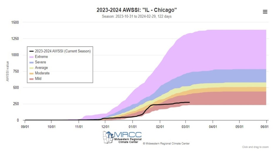
It's a gauge used by Midwest Regional Climate Center to assess what type of winter we are seeing. They keep an ongoing tally and rank the winter based on five categories. The categories, in order from least miserable to most miserable, include mild, moderate, average, severe, and extreme. By the end of February and meteorological winter, we were firmly in the "mild" category. The higher the number of the index, the worse the winter. To put our winter into perspective, the highest the index has ever reached through the end of February is 1305. The lowest it has been for this period is 230. We ended up with a winter AWSSI of 273.
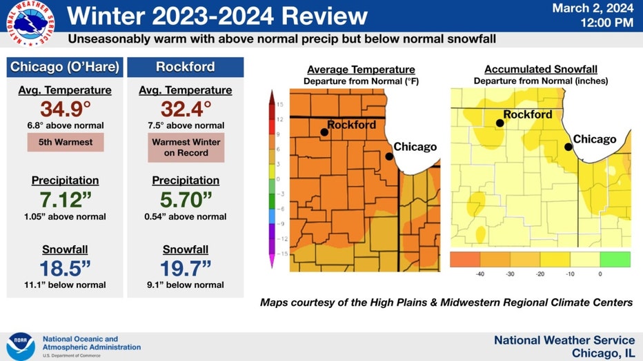
It was Chicago's 5th warmest winter on record, with an average temperature of 34.9 degrees, an amazing nearly 7 degrees above average. Our neighbors to the northwest in Rockford had their warmest winter on record. We finished the season with 18.5" of snow, which was nearly a foot below average. It was the 38th least snowy winter on record, which landed it in the top 30% of our least snowiest winters.
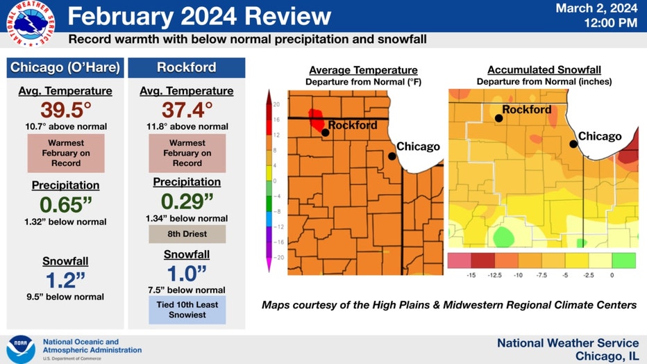
Our relatively snow-free February, which felt more like March, helped seal the deal on our easy winter. The month ended up nearly 11 degrees above average, making it the warmest February on record. There was just 1.2" of snowfall at O'Hare for the 12th least snowy February on record.
It looks like the first month of meteorological spring is going to pick up where the last month of meteorological winter ended in terms of temperatures.
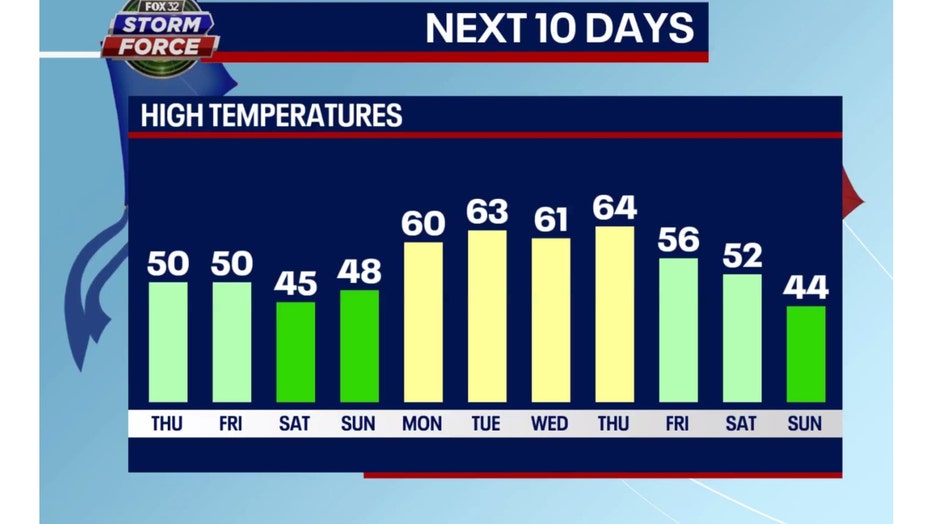
Our Fox Model extended high-temperature forecast takes us through the final days meteorological winter. Nine of the next ten days are forecast to be above average. The last day of this forecast, a week from this Sunday, is the only day to dip below the average mark. The 60s for highs Monday through Thursday next week are average temperatures for the middle of April.
Other models are also suggesting a mild middle of the month. The longer-range temperature outlooks from the Climate Prediction Center show a strong signal for a warmer-than-average overall middle of March.
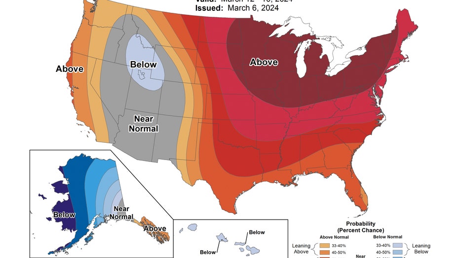
The 6-10 day temperature outlook forecasts northern Illinois and Indiana to be "likely above" normal overall. This covers the period from next Tuesday through the following Saturday. There is an 80% to 90% probability of being relatively warm during this time.
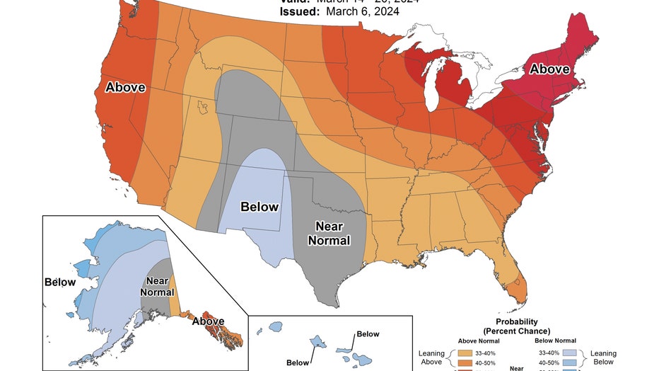
The 8-14 day temperature outlook shows a relatively warm pattern hanging around. It also forecasts Chicago to be "likely above" average. This covers the period from next Thursday through the following Wednesday.
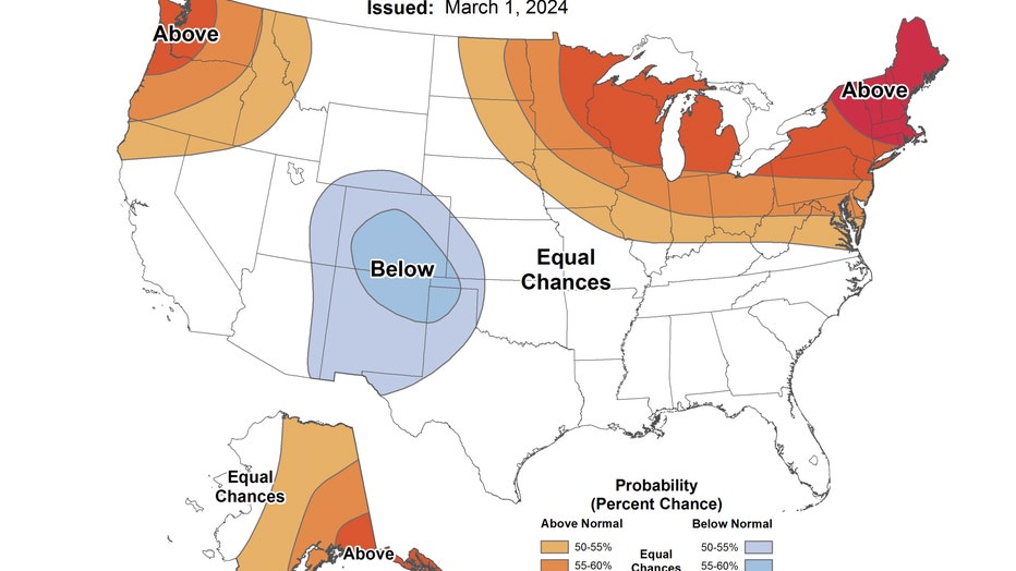
Last but certainly not least, the 3-4 week outlook keeps us favored for above-average temperatures overall for most of the last two weeks of March.