

Live weather updates: Strong storms pass through Chicagoland; warnings issued
CHICAGO - Severe weather is expected to develop across the central U.S. from the Midwest to the Great Lakes region on Wednesday, putting millions of people in cities like St. Louis, Indianapolis, Chicago and Detroit on alert for powerful storms that could be capable of producing damaging wind gusts, large hail and even some tornadoes.
Chicagoland Weather Alerts
- A Flash Flood Warning was issued for Kankakee County until 3:45 p.m.
- A Ground Stop was issued at Midway until 2 p.m. due to thunderstorms. A Ground Delay was issued at O'Hare — the average delay time is 109 minutes.
- A Tornado Watch was issued for parts of the Chicago area (south suburbs and NW Indiana) until 7 p.m.

Parts of Chicago area placed under Tornado Watch amid severe weather
Several counties in Illinois and Indiana are under a Tornado Watch as severe weather bears down on the Chicago area.
Live Updates:
- 6:55 p.m. - A Flash Flood Warning has been issued for Cook County and DuPage County until 8:45 p.m.
- 4:20 p.m. - The Tornado Watch issued for Chiocagoland has been canceled.
- 3:50 p.m. - Nearly 10,000 NIPSCO customers are without power due to the storms passing through. To see the latest power outage updates, click here.
- 3:45 p.m. - Reports of funnel clouds have come in with the line of storms to our Northwest. A Tornado Watch is in effect in Newton, Jasper and LaPorte through 7 p.m. Isolated weak tornadoes cannot be ruled out.
- 3:33 p.m. - Tornado Watch has been canceled for most of NE Illinois and in Lake and Porter Counties in Indiana. The watch is still in effect for Newton, Jasper and LaPorte through 7 p.m.
The backstory:
The action kicked off late Wednesday morning when a Tornado Watch was issued for more than 5 million people in parts of Illinois and Missouri until 4 p.m. CT.
The initial Tornado Watch included cities such as St. Louis and Cape Girardeau in Missouri, and Quincy, Springfield and Champaign in Illinois.
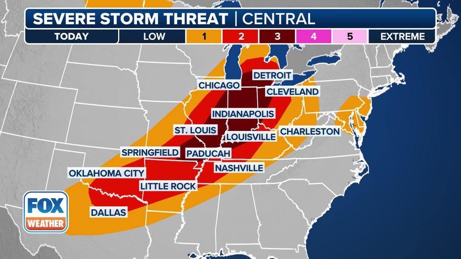
This graphic shows the severe weather threat on Wednesday, June 18, 2025. (FOX Weather)
This renewed risk comes after extreme weather tore across the Plains and Midwest over the past few days, producing tornadoes in Minnesota and Nebraska, while a record-breaking 101-mph wind gust was reported in Wichita, Kansas.
And the severe weather threat is expected to continue for the rest of the week, putting the mid-Atlantic, Northeast and New England on alert by Thursday.
The FOX Forecast Center said that the same cold front responsible for producing severe weather over the past few days is continuing to barrel across the U.S., and that’s what is fueling the threat on Wednesday.
NOAA’s Storm Prediction Center (SPC) has zeroed in on the Midwest and Ohio Valley, which is where the highest risk for storms is forecast to occur.
More than 15 million people in cities like Indianapolis and Fort Wayne in Indiana, Toledo and Dayton in Ohio and Louisville in Kentucky are under a Level 3 risk of severe weather on the SPC’s 5-point severe thunderstorm risk scale.
More than 38 million people from Texas to Michigan have been placed in a Level 2 out of 5 threat, including cities like Chicago, Dallas, Detroit and St. Louis.

While parts of the mid-Atlantic, including Washington, Baltimore and Philadelphia, will see the threat of severe weather on Wednesday, a larger threat exists along the Interstate 95 corridor on the East Coast on Thursday.
More than 62 million people from North Carolina to the U.S.-Canada border in Maine were placed in a Level 2 out of 5 threat for Thursday.
This includes cities like Charlotte and Raleigh in North Carolina, Richmond in Virginia, Washington, Baltimore, Philadelphia, New York City, Hartford in Connecticut and Burlington in Vermont.
The main threats from storms that develop on Thursday will be damaging wind gusts and hail.
However, there is also a low chance of tornadoes from northern Virginia into the Hudson Valley of New York state and into Vermont, New Hampshire and Maine in northern New England.