

Chicago weather: Storms moving in this morning, cooler air arrives midweek
LIVE UPDATES: Severe weather threatens Chicagoland, tornadoes possible
CHICAGO — Showers and storms are queued up near the Mississippi river as of this writing and are beginning to move into far-northwest Illinois. This activity will move into our area later this morning and its intensity remains in question.
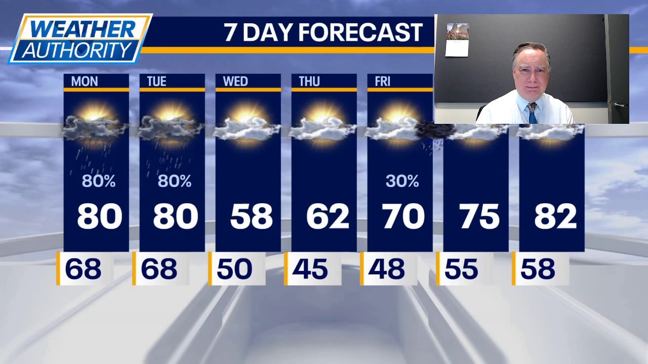
The risk of a severe thunderstorm is not zero but it’s looking mighty low because of the time of day that the storms are moving in. Their arrival will also stymie much of a warm-up, even though temperatures have remained unseasonably mild overnight in the 70s for the majority of our area. Highs may get to 80 but that would be about it. There will be a gusty southwest wind at times reaching 30 mph outside of any thunderstorms.
Later in the afternoon and this evening, it will be breezy with a slight chance of another t’shower. Temperatures will move back into the upper 70s.
Live severe weather updates
- A Severe Thunderstorm Warning has been issued for Will, Grundy and Kendall counties until 11 a.m.
- A Severe Thunderstorm Watch has been issued for most of the Chicago area and northwest Indiana until 5 p.m.
What's next:
Tomorrow may have a similar footprint of shower and thunderstorm activity with the bulk of it happening during the morning and or early afternoon hours. In fact, it’s possible that much of the area will miss out on rainfall altogether tomorrow with a bias towards our southern counties. Highs will once again be close to 80° ahead of the cold front that will sweep through late in the afternoon.
Sharp midweek cooldown in Chicago
Behind that front we will have a couple of cooler days Wednesday and Thursday with highs on Wednesday struggling to hit 60 then barely in the 60s on Thursday. Both days will be cooler by the lake.
That trend will continue even as temperatures climb Friday, Saturday and Sunday. Highs on Friday will be close to 70 and then reaching 80 by Sunday. The highest chance of any rainfall during those three days will be Friday night.
The Source: The information in this forecast came from FOX Chicago's Mike Caplan.