

Chicago winter weather outlook: What to expect from the city's coldest season
February 17th, 2021 https://www.barrybutlerphotography.com/
CHICAGO - I'm sticking my meteorological neck out once again with my official forecast for the winter of 2022-2023. I tried this last year and wasn't too badly embarrassed by the results. My prediction of a below average winter temperature of between 28.4 degrees and 29.4 degrees turned out to be accurate.
We ended up with an average temperature of 28.7 degrees for the winter of 2021-2022. My results weren't quite as good when it came to a snowfall forecast. I forecast an above average winter for snowfall with a range between 33 inches to 37 inches. We ended up with 28.6 inches, or 1 inch below average for winter.
First some forecast methodology and model comparisons before I get to my forecast.
SUBSCRIBE TO FOX 32 ON YOUTUBE
My forecast will be for meteorological winter or the months of December, January and February. The official forecast from NOAA is calling for "equal chances" of temperatures being above or below average during this period. This suggests we should be around average this winter.
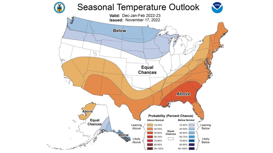
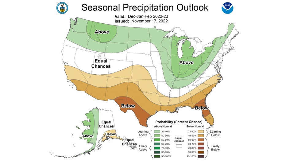
The forecast for precipitation has us favored to be above average for the season. It doesn't break out that precipitation into rain versus snow but seems to suggest above average snowfall.
Probably the biggest influence on a winter forecast is the presence or absence of an El Niño or La Niña. The temperature of Pacific Ocean near the equator compared to average can have a big impact on our winter weather. This is an example of a teleconnection or more simply, "changing conditions in one part of the world can affect areas far from the source."
A moderate La Niña is predicted for our winter months. We can go back in the record books and see the influence of previous similar conditions on our winters. According to state climatologist Dr. Jim Angel, these are impacts of La Niña in Illinois:
- Summers have a tendency to be warmer and drier in Illinois
- Falls have a tendency to be cooler in the north and wetter in the southeast
- Winters are typically warmer and wetter than average with more snow and winter storms
- Springs tend to be cooler across most of the state and drier in the west
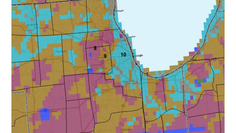
National Weather Service climatologist Dr. Brian Brettschneider posted the graphic below recently that shows the number of winters that had above average during the presence of a moderate to strong La Niña.
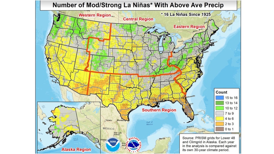
I reached out to him to see a more detailed analysis for northern Illinois. The graphic below breaks down our area even further and shows that most of northern Illinois and Indiana saw between eight to 10 winters with more than average precipitation. That means that half to a bit more than of the winters with similar conditions to what we are seeing now in the Pacific saw above average precipitation.
That would support NOAA's forecast that is leaning towards more precipitation than normal for our upcoming winter.
I also checked a couple of other forecasts in addition to the National Weather Service official forecast.
AccuWeather's winter forecast covers the months from October through April. It forecasts snowfall between 75% to 124% of average. This seems to suggest a forecast favoring around average snowfall.
The upper Midwest north of here is favored for above average snowfall and the Missouri Valley, Tennessee Valley and Ohio Valley regions are favored for below average snowfall.
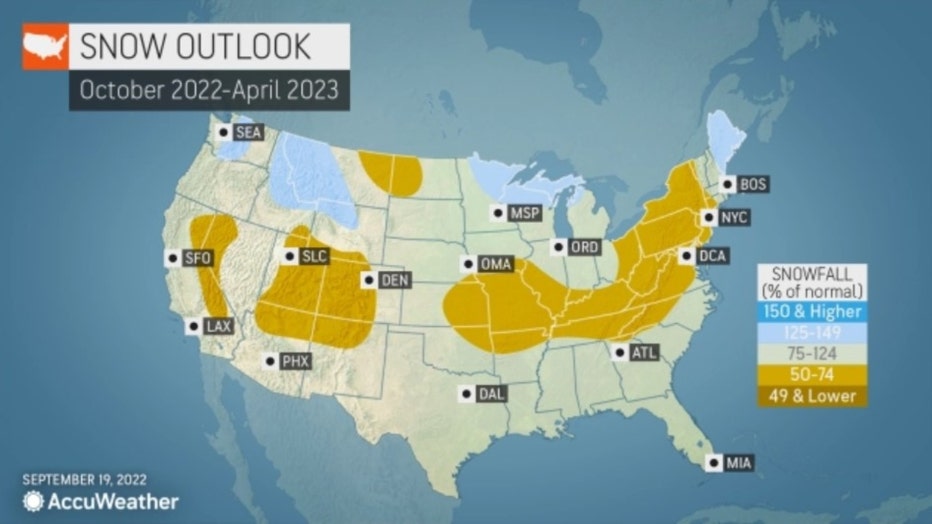
They forecast more of a "seasonal snowfall" or snow that occurs in the winter months and also includes snowfall from some of the months outside of official winter. The average "seasonal snowfall" for O'Hare is 38.4 inches.
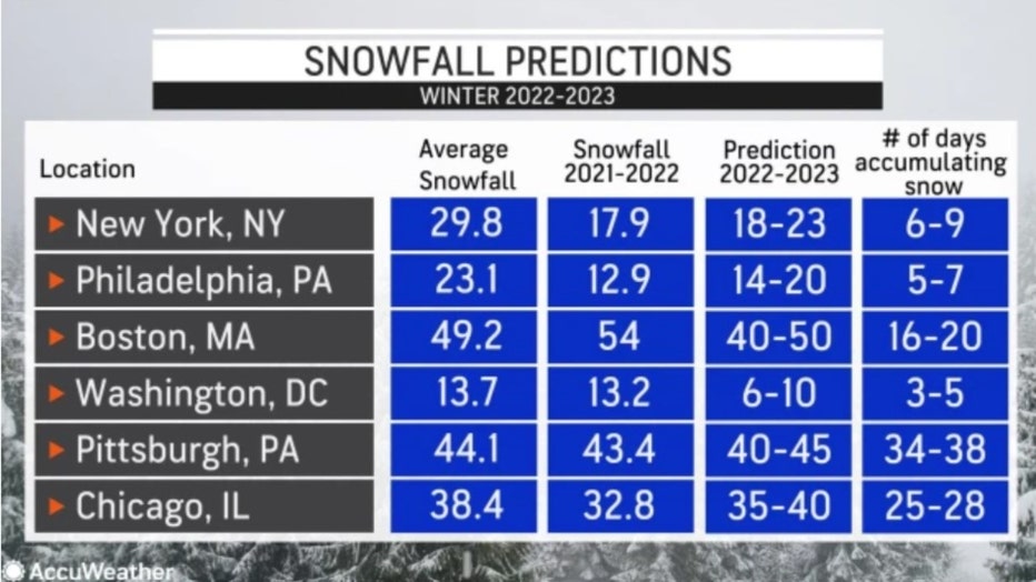
They are also bold enough to give an exact range of snowfall for their forecast. The 35 inches to 40 inches they are predicting ranges from about three inches below average to about two inches above average for seasonal snowfall.
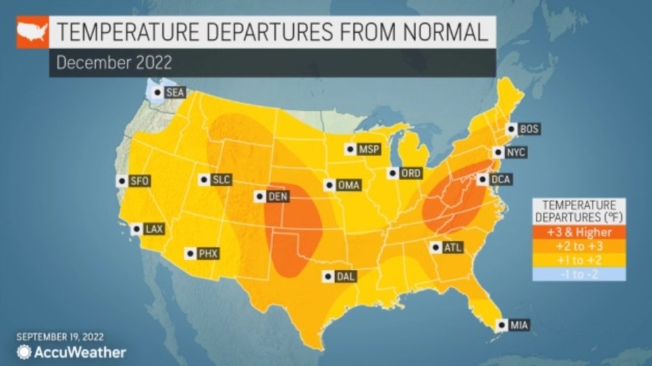
AccuWeather's temperature forecast has our winter coming in around 1 degree to 2 degrees above average.
Two of the main models I check this time of the year are the European model or ECMWF and the Climate Forecast System Version 2 or CFSv2.
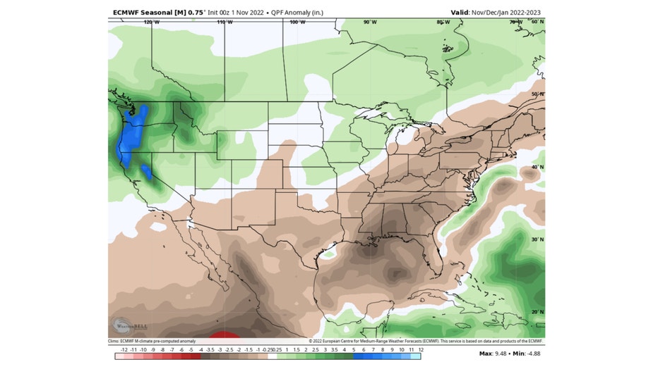
The ECMWF model has most of the Chicago area forecast to be around average for winter precipitation. Our far northwestern and southern suburbs along with northern Indiana are favored for below average precipitation.
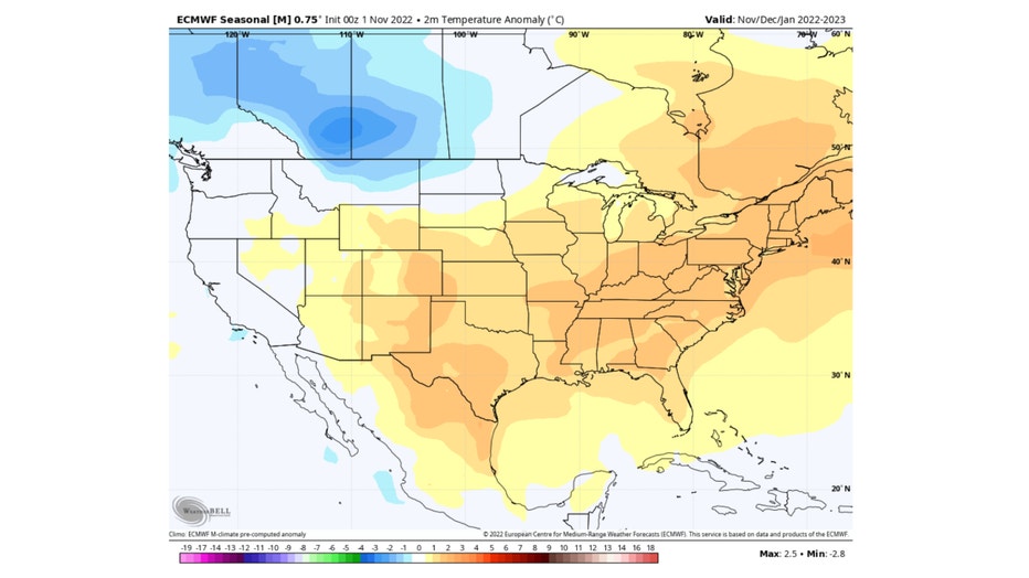
The ECMWF model has us (along with most of the country) favored for above average temperatures. The only places favored for a below average winter in terms of temperatures is central and northern Montana and northwestern North Dakota.
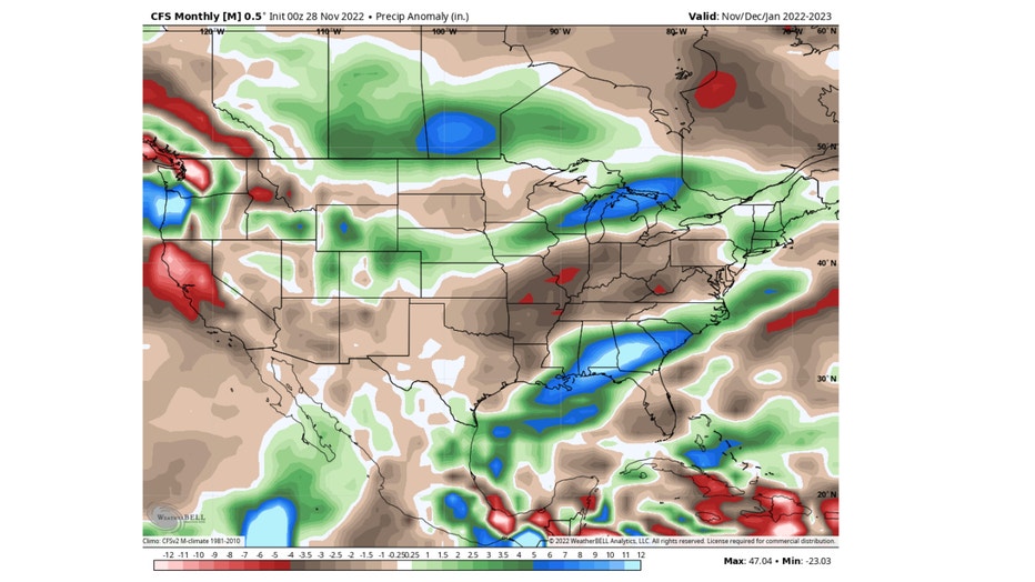
The CFSv2 model has northern Illinois split between favoring below average precipitation from he city southward and above average north and west of Chicago. Bisecting these two areas is a thin slice of the Chicago area forecast to be right at average for winter precipitation.
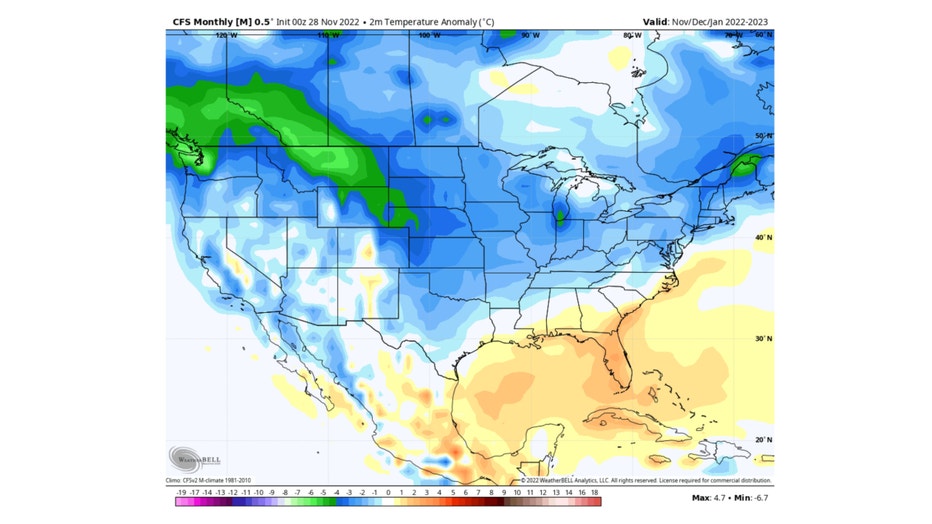
The CFSv2 model has us forecast to be around 3 to 4 degrees below average this winter.
Now it is time for my meteorological rubber to meet the road. After careful consideration and a few prayers, here is my official forecast for the winter of 2022-2023:
Snowfall-I predict above average snowfall between 31 inches to 36 inches this winter (29.6 inches is average)
Temperature-I predict an about or just above average winter temperature of between 26 degrees to 28 degrees (26.4 degrees is average)
I'll check back in sometime in March to see how I did.