

Chicago's winter is about to get more miserable

Afternoon forecast for Chicagoland on Jan. 31st
FOX 32's Tim McGill breaks down today's weather outlook and takes a peek ahead to the rest of the week.
Chicago - Our winter started off relatively mild and quiet way back in December.
For the month we were a whopping 7.5 degrees above average at O'Hare. Snowfall in December totaled a measly 1.9 inches which was 5.7 inches below average.
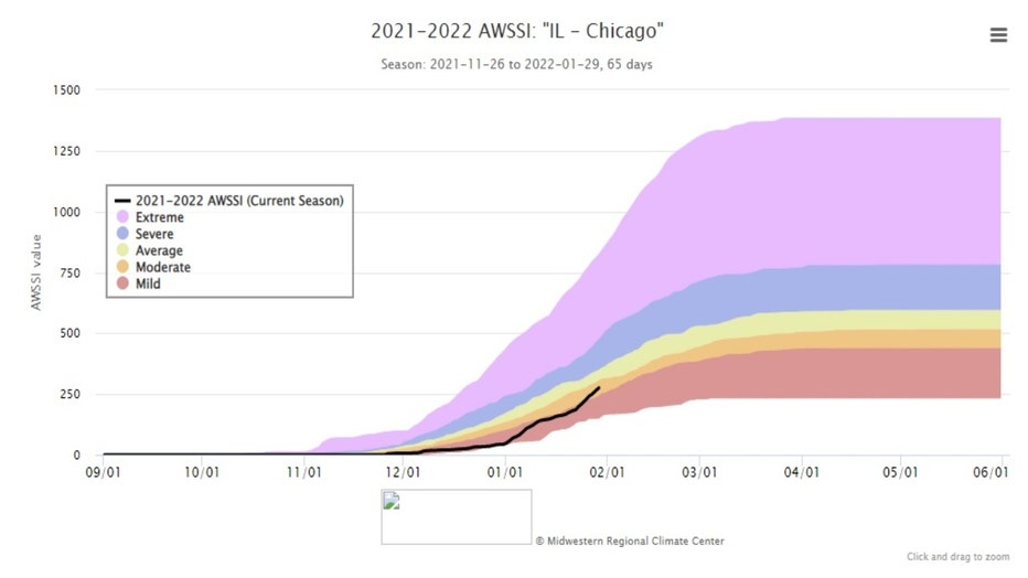
January hasn't been as easy. So far for the month, O'Hare is running nearly 5 degrees below average with 13.9 inches of snow (3 inches above average). The Midwest Regional Climate Center has developed an objective way to measure the amount of misery a particular winter gives us.
FORECASTS UNCERTAIN AS MAJOR WINTER STORM APPROACHES CHICAGO
The Accumulated Winter Season Severity Index or winter "misery index" had us in the "mild" category through the first part of January but has recently pushed us into the "moderate" category. That is the second least severe category possible. The categories in descending order of misery also include "average", "severe" and finally "extreme".
The index is based on "the intensity and persistence of cold weather, the amount of snow, and the amount and persistence of snow on the ground". A prolonged period of snow is forecast beginning early Wednesday morning and lasting through most of Thursday. In other words, our winter is about to become more miserable.
First, some obligatory words of caution. The track and intensity of the systems that are headed our way are far from certain. This is a complex forecast scenario. A slight shift in the track or inability for the storm to organize fully could have huge impacts on snowfall amounts. The forecast will undoubtedly be refined between now and the arrival of snow early Wednesday so stay tuned!
One way to get a handle on the snowfall forecast is to consider a model ensemble such as the GEFS. Here is the National Weather Service explanation of how the Global Ensemble Forecast System works:
The Global Ensemble Forecast System (GEFS) is a weather forecast model made up of 21 separate forecasts, or ensemble members. The National Centers for Environmental Prediction (NCEP) started the GEFS to address the nature of uncertainty in weather observations, which are used to initialize weather forecast models.
The proverbial butterfly flapping her wings can have a cascading effect leading to wind gusts thousands of miles away. This extreme example illustrates that tiny, unnoticeable differences between reality and what is actually measured can, over time, lead to noticeable differences between what a weather model forecast predicts and reality itself.
The GEFS attempts to quantify the amount of uncertainty in a forecast by generating an ensemble of multiple forecasts, each minutely different, or perturbed, from the original observations.
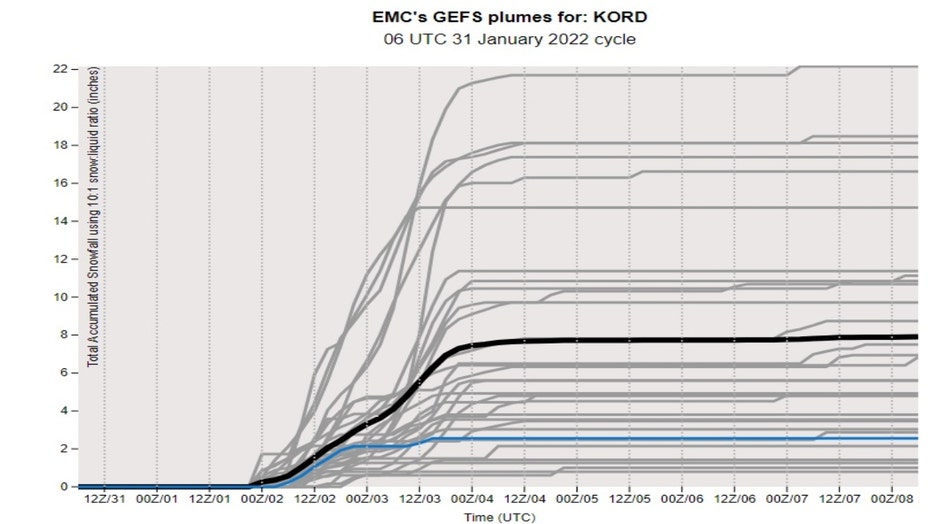
The snowfall "plumes" for the model shows various solutions for the amount of snowfall that could on the way. On the low end the model only spits out an inch or two of snow but on the high end the model squeezes out nearly two feet. The average seems to be around 8 to 10 inches for O'Hare.
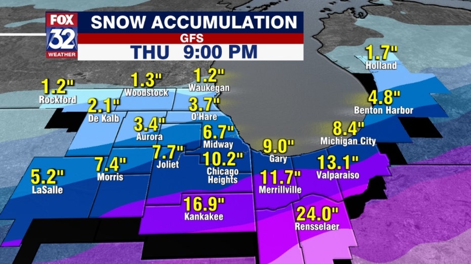
The track of the storm seems to favor areas south of the city for the heaviest snowfall. The GFS model has around 6 to 10 inches of new snow falling in Chicago with almost 17 inches well south of the city in Kankakee.
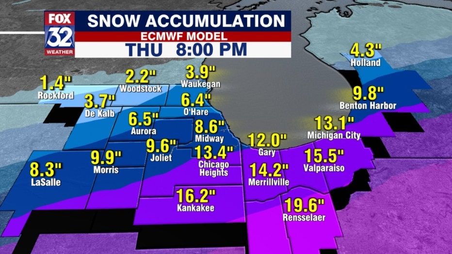
The European model has similar numbers but a greater range for Cook County in particular. It has anything from 6 inches to nearly a foot from O'Hare to the southern end of the county. The possibility of lake-effect enhancement Wednesday night into Thursday makes this forecast even more difficult. The capricious nature of Friday's lake-effect snow event is a reminder of just how tough forecasting totals can be when Lake Michigan is involved.