

Lack of ice means Chicago's lake-effect snow machine is ready for business
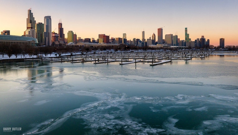
Some ice but plenty of open water along lakefront | Barry Butler Photography
CHICAGO - Snow lovers had reason to be happy this past weekend, especially if you live north and northwest of Chicago. Up to 8 inches of snow fell in our far northern suburbs. O'Hare officially recorded 2.3 inches of snow. This helped closed the gap a bit compared to average snowfall for the season so far but we are still down a little more than 6 inches.
We had a fairly dramatic pattern change kick in at the end of last week after a long streak with relatively mild days.
We saw 29 straight days above average from Dec. 18 through Jan. 25 but we are closing out this month cold.
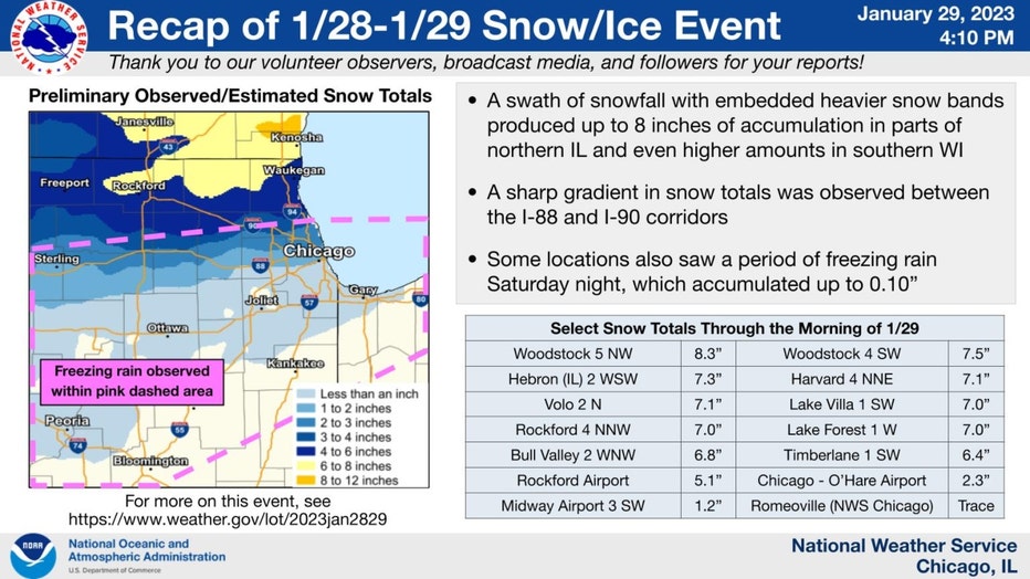
Summary of our weekend snowfall.
Five of the last six days (including today) have been below average. Our colder pattern developed late last Wednesday. Since that day and the following five days we have picked up 7.6 inches of snow at O'Hare or 77% of our total snowfall for January so far and 37% of our total snowfall for the season.
It should be obvious that cold is one of the key components to getting snowfall. Storm systems with cold enough air, sufficient moisture and a mechanism for lifting that air, is one way of getting snowfall here but there is another.
Cold enough air blowing over the relatively warmer waters of Lake Michigan can squeeze out snow too, even in the absence of an organized storm system. Lake-effect snow is a frequent contributor to our seasonal snowfall in Chicago and with Lake Michigan almost ice free, the lake-effect snow machine is open for business provided a cold wind is blowing in our favor in the right direction.
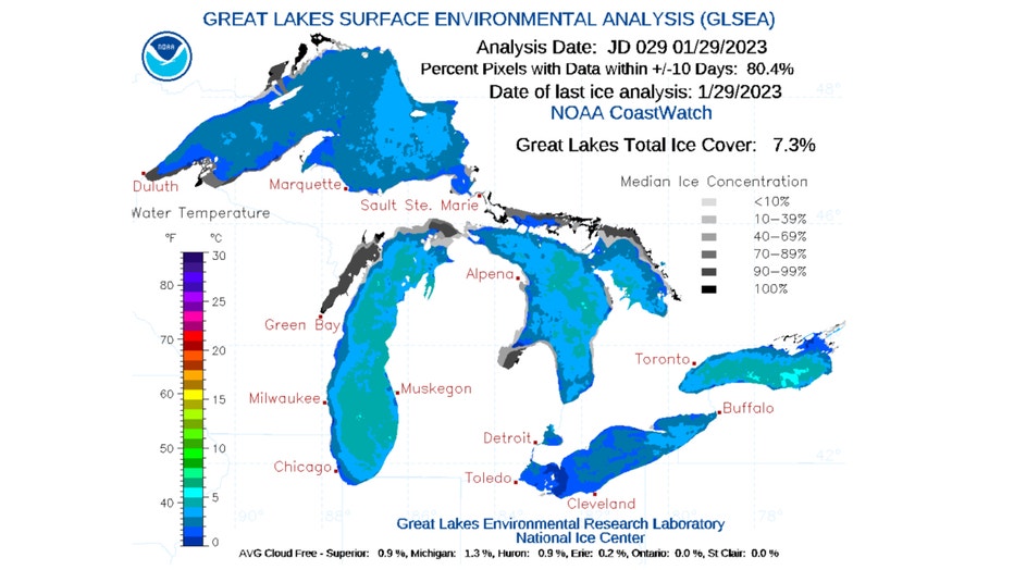
Nearly 93% of the Great Lakes does not have significant ice cover.
More than 90% of the Great Lakes does not have ice cover. We had about four times the ice cover last winter at this time. The recent cold has meant more ice forming but a warm-up next week and relatively mild pattern beyond that means there will be a lot of open water on Lake Michigan.
The National Weather Service office in Grand Rapids, Michigan has a good summary of the factors that influence lake-effect snow:
Forecasting lake effect snow is a significant forecasting challenge in the Great Lakes during the winter months. There are numerous factors that determine the intensity and location of lake effect snow bands including the available moisture, instability (propensity for the air to rise if forced upwards), wind speed, and wind direction to name a few. One factor that is important with respect to the intensity of lake effect snow is the "fetch". Fetch is essentially the distance that air must travel from the upwind side of the lake (Wisconsin) to the downwind side of the lake (Michigan). A longer "fetch" enables more warmth and moisture to be added to the air as it crosses the lake and this typically results in stronger lake effect snow bands As for the location of where the heaviest snow will fall over land, wind direction is probably the most important factor.
The upwind side of the lake for Chicago is really anything north and east of the city. The downwind side for us is the Illinois shoreline. The wind that squeezes out the most snow and gives us the best "fetch" is out of the north/northeast. The longer that colder air moves over the length of Lake Michigan, the better. The more open the water, the better too.

There have been some years when the Great Lakes have nearly frozen over entirely at some point during the winter. The chart above shows nine winters stretching back to the early 70s when 80% or more of the lakes surface had ice cover. Without open water there is no lake-effect snow.
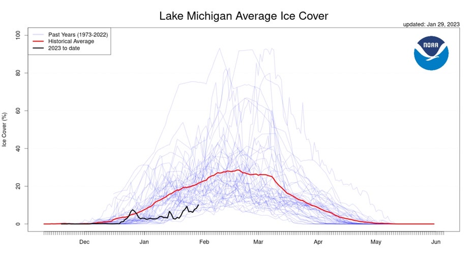
Lake Michigan's ice cover is running well below average.
The red line in the graphic above shows the historical average of Lake Michigan ice cover for about the last 50 years. The black line shows the changes in ice cover so far this winter. We are running well below average at this point and longer range outlooks seem to suggest that will not change much.
The Climate Prediction Center's long range temperature outlooks have more tans and browns than blues lately. There is a fairly strong signal that much of the eastern half of the country will be in a mild pattern into the middle of February.
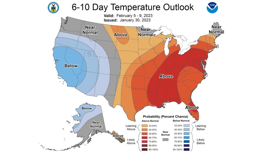
The 6-10 day temperature outlook has us "likely above" average overall for the period from this Sunday through the following Thursday.
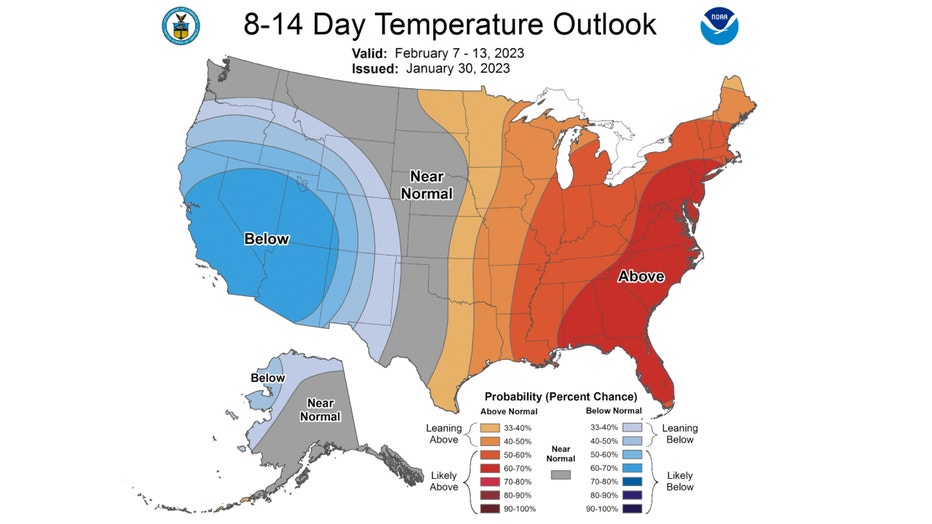
The 8-14 day temperature outlook also has us forecast to be "likely above" average too. This covers the period from next Tuesday through the following Monday.
These outlooks suggest there will be even less ice in the days to come for not just Lake Michigan but all of the Great Lakes.