

Chicago weather: Powerful winds, large hail blow through area

Powerful winds push through Chicagoland, leaving behind some damage
Chicagoland saw strong winds and heavy rain Thursday night as storms barreled through the area.
Weather Watches and Warnings:
- A Tornado Watch has been issued for McHenry County and Lake County, Ind. until 10 p.m. and all of Chicagoland/NW Indiana until 10 p.m.
- A Severe Thunderstorm Warning has also been issued for Grundy, Will and Kankakee Counties until 8:45 p.m.
- A Severe Thunderstorm Warning has been issued for Chicago, Joliet and Cicero until 8:45 p.m., according to the National Weather Service.
- A Severe Thunderstorm Warning has been issued for Lake County, Ind. until 9:15 p.m.

Live Updates:
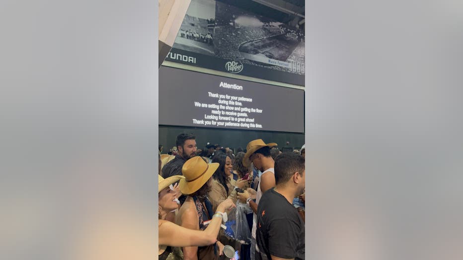
9 p.m. - Tornado Watch Issued; Soldier Field Fans Let Back Inside
CHICAGO - A Tornado Watch has been issued for Lake County, Ind. until 10 p.m.
Fans at Soldier Field for the Beyoncé concert were let back inside following a weather delay.
Beyonce fans let back into Soldier Field after rain delay at concert. (FOX 32 )
8:32 p.m. - Severe Thunderstorm Warning
A Severe Thunderstorm Warning has been issued for Lake County, Ind. until 9:15 p.m.
8:15 p.m. - Fans Shelter in Place at Soldier Field
Sources tell us fans are being ordered to shelter in place at Soldier Field due to severe weather as they wait for the Beyoncé concert. The show was initially planned to start at 7 p.m. but was pushed back. The cutoff time for the show is midnight.
7:50 p.m. - More Severe Thunderstorm Warnings
A Severe Thunderstorm Warning has been issued for Chicago, Joliet and Cicero until 8:45 p.m., according to the National Weather Service.
Beyoncé concert update: A representative at Soldier Field said the end time of the show, regardless of the start time, will end at midnight.
7:39 p.m. - Severe Thunderstorm Warnings Issued
A Severe Thunderstorm Warning has been issued for DuPage, NE Cook, and SE Lake (IL) Counties until 8:15 p.m. Wind gusts reaching 60 mph and quarter-sized hail are possible.
Another Severe Thunderstorm Warning has been issued for Grundy, SW Will and NW Kankakee Counties until 8:45 p.m. Wind gusts reaching 60 mph and quarter-sized hail are possible as well.

Beyoncé concert at Soldier Field delayed as fans wait out weather
Fans are anxiously waiting for the Beyoncé concert at Soldier Field. The show is delayed due to possible severe storms passing through the Chicago area.
7 p.m. - Beyoncé Concert Delay Impacting Fans
FOX 32's Dane Placko is at Soldier Field ahead of Beyoncé's "Cowboy Carter" concert tonight. The show is delayed due to the storms passing through the Chicago area and fans' excitement hasn't dwindled.
6:45 p.m. - Severe Thunderstorm Warnings Extended
Severe Thunderstorm Warnings have been extended into northern Kane County and all of McHenry County until 7:30 p.m. Wind gusts of up to 60 mph are possible.
6:18 p.m. - Severe Thunderstorm Warning Issued; O'Hare Airport Delays Continue
A Severe Thunderstorm Warning has been issued for northern Cook County and Lake County (IL) until 7 p.m. Wind gusts reaching 60 mph and quarter-sized hail are possible.
The delays at O'Hare Airport are ongoing. Departures to O'Hare are delayed by an average of 124 minutes due to thunderstorms.
6 p.m. - Severe Thunderstorm Warning Issued
A Severe Thunderstorm Warning has been issued for northern DeKalb and McHenry Counties until 7:30 p.m. Quarter-sized hail and 60 mph wind gusts are possible.
5:24 p.m. - Ground Stop at O'Hare Airport
A ground stop has been issued at O'Hare International Airport until 6:15 p.m. due to thunderstorms in the Chicago area.
5:15 p.m. - Tornado Watch issued for Chicagoland
A Tornado Watch has been issued for all parts of Chicagoland, including Northwest Indiana, until 10 p.m. Large hail, damaging winds and tornadoes are possible with any storms that become severe.
4:51 p.m. - Severe Thunderstorm Warning Issued
A Severe Thunderstorm Warning has been issued in Winnebago County until 5:30 p.m. Wind gusts reaching up to 60 mph and quarter-sized hail are possible.
4:30 p.m. - Beyoncé concert delayed due to weather
A spokesperson with Soldier Field confirmed to FOX 32 on Thursday that Beyoncé's "Cowboy Carter" show will not start before 9 p.m. due to the weather in the Chicago area. We'll bring more updates as they become available.
Full Forecast :
A week-long severe weather threat ramps up Thursday across the Midwest, with Chicago, Milwaukee and other major cities bracing for powerful storms capable of producing hurricane-force wind gusts, baseball-size hail or larger, and strong tornadoes.
Thursday is also shaping up to be the hottest day of the week, with temperatures climbing into the upper 80s and low 90s. Chicago’s record high for May 15 is 91 degrees, and it may be challenged.
The National Weather Service and NOAA’s Storm Prediction Center have placed more than 23 million people—including residents in Chicago, Milwaukee, Madison and St. Paul—under a Level 3 enhanced risk on the 5-point severe thunderstorm scale.
Storms are expected to develop by mid-afternoon as a cold front collides with deep Gulf moisture and atmospheric instability. Supercells may form first, followed by a line of storms sweeping northeast through the evening hours.
Some storms could bring hail over 2 inches in diameter, 75+ mph wind gusts, and tornadoes rated EF-2 or stronger.
Severe weather timeline

What to do in a hail storm
If you're caught in a storm with large hail while driving:
- Pull off the road if possible and point your vehicle into the wind. The windshield is the strongest window.
- DO NOT park under overpasses. This can block the flow of traffic, including for emergency vehicles.
- Cover yourself in case the windshield shatters. Jackets or floor mats are a good option.
Record high temperature
Chicago set a new record high temperature at O'Hare Airport on Thursday. We hit 92 degrees. The previous record was 91, set in 1962.
Future forecast
What's next:
Thursday night will bring clearing skies and lows in the low 60s, but the severe threat returns Friday afternoon and evening with more storms likely, some potentially strong to severe again.
The weekend turns cooler and calmer, with sunshine expected and highs in the 60s Saturday and Sunday.
Partly sunny skies and more mid-60s highs are forecast for Monday, with additional rain chances arriving Tuesday and Wednesday.
The Source: Details for this story were provided by Fox 32 Meteorologist Kaitlin Cody, FOX Forecast Center, NOAA Storm Prediction Center, and the National Weather Service.