

Signs of spring and winter in Chicago this week

Signs of spring and winter in Chicago this week
Signs of spring have been showing up in Chicago. We also have to deal with some signs of winter the next several days.
CHICAGO - The days are getting longer and the nights are getting shorter. That is one of several signs of spring in Chicago this week.
Wednesday was 11 hours and 34 seconds long. We are adding just under 3 minutes of daylight each day in March. By the end of the month, we will enjoy 1 hour and 5 more minutes of daylight.
Daylight-saving time begins this Sunday. The sun will set 1 hour and 5 minutes later than today. It will sink under the horizon around 6:53 pm on March 12.
The boys and birds of spring are other signs of the season. The Cubs will play their home opener at Wrigley Field in just three weeks from Thursday when they host the Milwaukee Brewers. The White Sox will play their first game of the regular season on the same day when they take on the Astros in Houston.
There have been more cardinal (the birds and not the baseball players) sightings recently, and also more sightings of sandhill cranes. White pelicans have made their pilgrimage to the Chain of Lakes. They're hard to miss with their impressive nearly 5-foot wing span.

2022 dyeing of Chicago River for St. Patrick's Day
Green is one of the dominant colors of spring. The Chicago River will be dyed green this Saturday in honor of St. Patrick's Day.
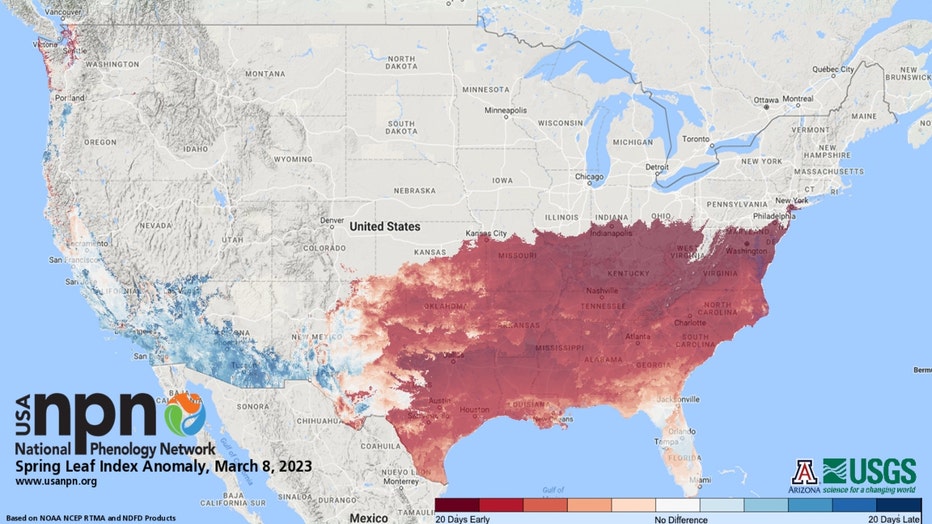
Spring leaf index anomaly for March 8
The National Phenology Network keeps track of their "spring leaf index" that monitors the first leaf and first bloom of certain plants to get an indication when spring has started based on these observations. The map above shows the anomaly, or difference between this year's index and the 30-year average ending in 2020. It appears that spring has sprung early (as much as nearly three weeks in spots) from the Gulf Coast northward into southern Illinois.
Even with all these signs of spring we still can't completely escape wintry weather. We have some signs of winter this week that might include some sticking snow Thursday night into Friday. A colder weather pattern is also ready to kick in soon.
Let's talk about the snow first.
Last Friday was a good reminder that snowfall forecasts can be tricky at best. Models were predicting an impressive storm with significant snow that ended up steering south with less snowfall than they had forecast. That being said, I will still share some computer model forecasts, but caution that it is still too early to put your faith in these numbers. The projections below were gathered from model data on Wednesday and will undoubtedly change before the first flakes fly Thursday.
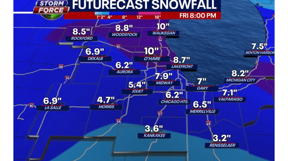
The GFS model is showing some robust snowfall numbers. It favors areas north of the city with heavier amounts that would reach to nearly 10" in total. It squeezes out around 8 to 9 inches in the city and then tapers amounts off to around 3 to 4 inches south of the city. These numbers seem high and I tend to agree more with the Baron model numbers below.
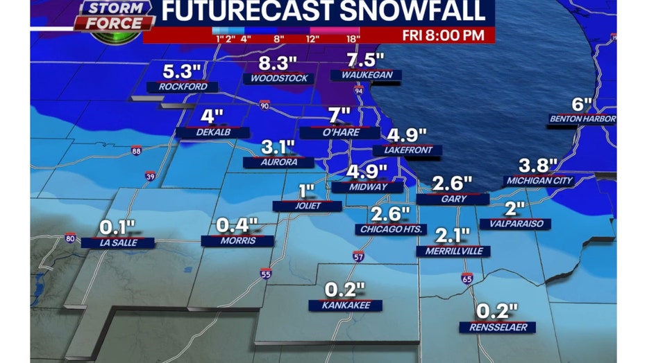
Our Baron Model also favors areas north of the city for heavier snowfall with as much as 8 inches there. The city gets around 5 inches. As we head south of the city the numbers taper off quickly to just a trace or so in Kankakee.
These numbers are not set in stone. The main message is that some heavy wet snowfall will accumulate in at least a part of our area. The storm track seems to suggest our northern suburbs will bear the brunt of it. The Thursday evening commute may be impacted a bit but Friday morning's commute is when we face the biggest impact.
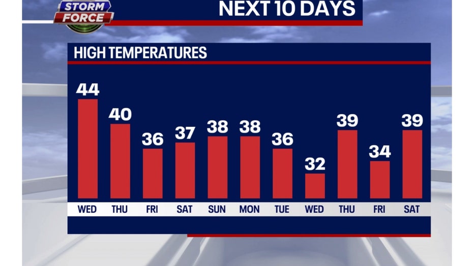
Our model also suggests a colder pattern will stick around for several days making it feel more like February than March. After today the next ten days in a row may be below average.
The Climate Prediction Center's long-range temperature outlook seems to agree.
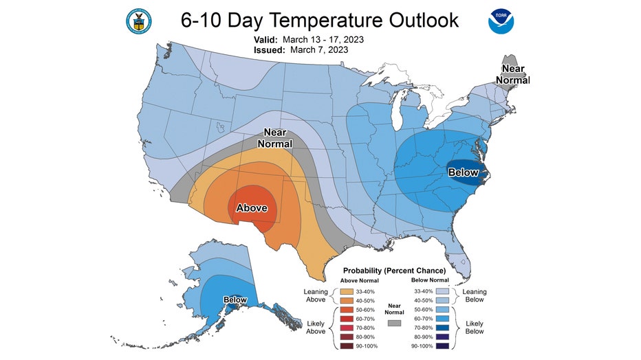
The 6-10 day temperature outlook has us "likely below" average overall from next Monday through the following Friday.
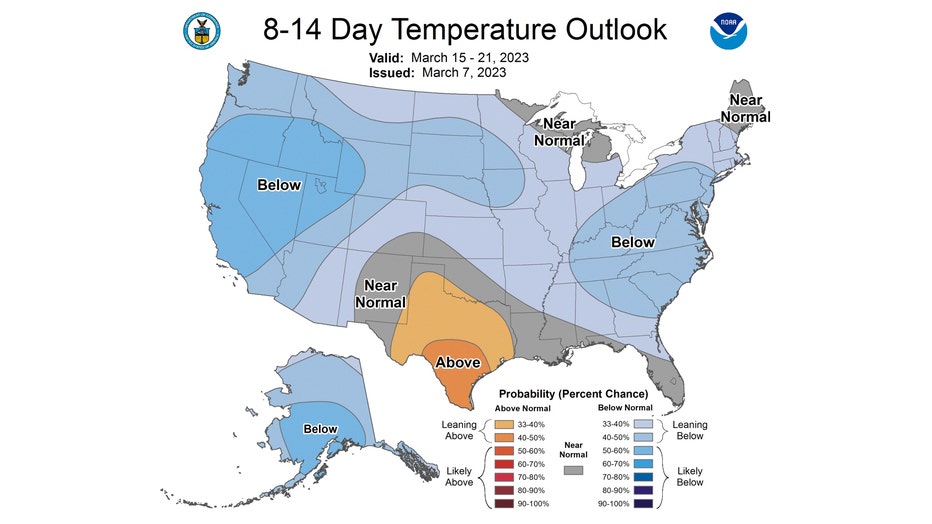
The 8-14 day temperature outlook also favors us to be below average overall. We are "leaning below" average next Wednesday through the following Tuesday. Most of the country is forecast to either be "leaning below" or "likely below" average during this period.
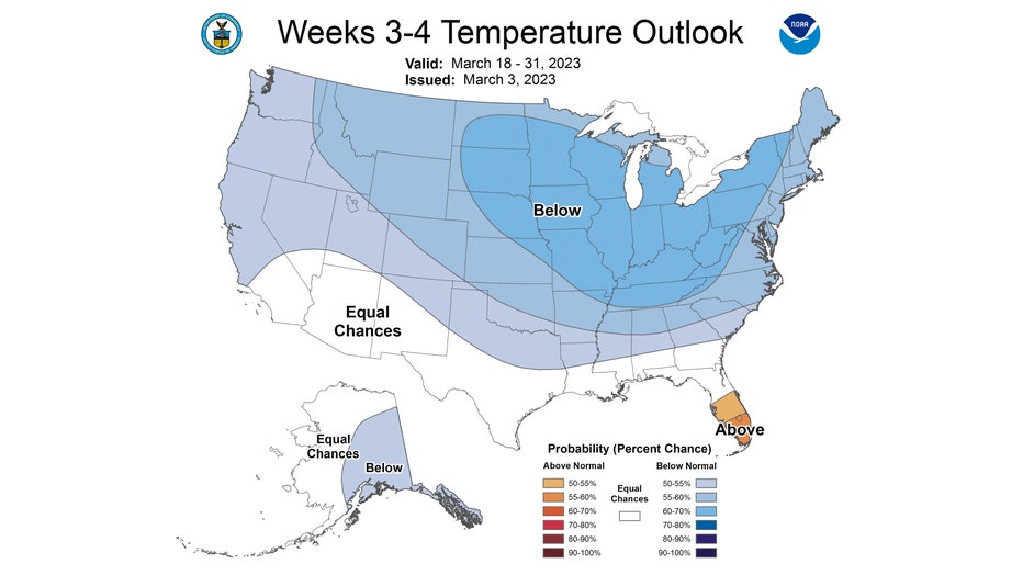
The updated longer range 3-4 week temperate outlook has most of the country covered in blue. We have a 60 to 70 percent probability of being below average for the last two weeks of March.
If you end up shoveling snow later this week, just remember it should melt away fairly quickly. Hopefully the signs of spring will soon start to outnumber the signs of winter.