

Strap in for a bumpy weather ride in Chicago
Chicago - Sunday's high of 64 degrees was the warmest we have seen at O'Hare in nearly three weeks. There is more where that came from.
Highs Monday through Wednesday should be above average. Temps in the 60s will return Tuesday, and then we should soar into the 70s with the help of gusty southerly winds on Wednesday.
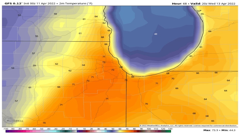
The GFS model has lower 70s here Wednesday afternoon. The forecast for 3 p.m. that day shows 70s nudging all the way north into southeastern Wisconsin. This forecast also shows the fairly dramatic drop in temperatures just to our west as a cold front presses eastward. Temperatures tumble into the lower to middle 50s just behind that front.
DOWNLOAD THE FOX 32 WEATHER APP FOR ALERTS
This sharp drop in temperatures is just one of several ingredients that will be in place to bring us the possibility of severe storms this week.
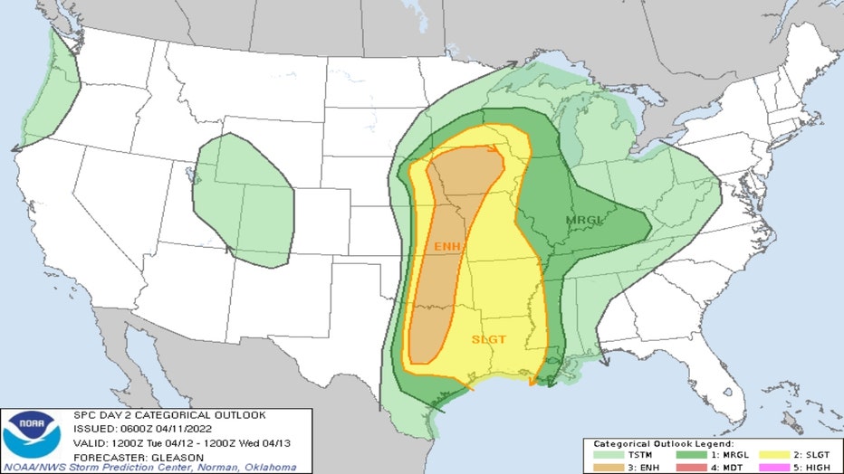
SPC Outlook For Tuesday/Tuesday Night
The Storm Prediction Center has placed us in a "marginal" risk for severe weather for the period of Tuesday through Tuesday night. The risk for severe weather increases to our west and southwest. A strong low pressure system spinning out of Colorado will drag a cold front trailing south from it across the plains and toward the Midwest. Warmer and more moist, unstable air surging north out of the Gulf of Mexico will be lifted by the colder, more dense air behind the front. Wind shear (a change in wind speed and/or direction over a relatively short distance) will probably also contribute to spin up some severe storms.
A couple of storms could reach severe limits in northern Illinois. The greatest threat would be damaging winds and large hail during the middle or latter part of Tuesday. That would be the exception though since most of us should be dry.
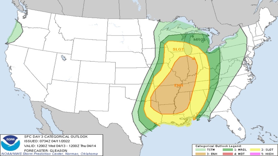
SPC Outlook For Wednesday/Wednesday Night
The Storm Prediction Center raises our risk for severe weather in its Wednesday through Wednesday night outlook. There is a "slight" risk of severe weather for most of our area with a "marginal" risk in our southern suburbs and portions of northwest Indiana.
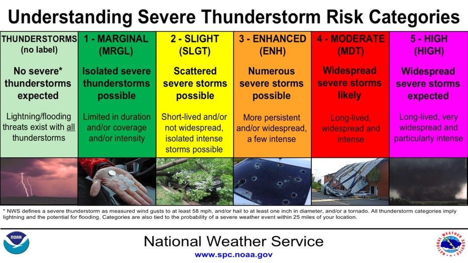
Slight risk means scattered severe storms possible while enhanced risk means numerous severe storms are possible. All varieties of severe weather are possible from damaging winds, large hail to even tornadoes.
The low over Colorado Tuesday will sweep east into southern Minnesota by early Wednesday and then northward into its arrowhead by early Thursday. The same basic setup will be in place as discussed for Tuesday and Tuesday night, but the most volatile portion of this system will be moving through the Midwest Wednesday.
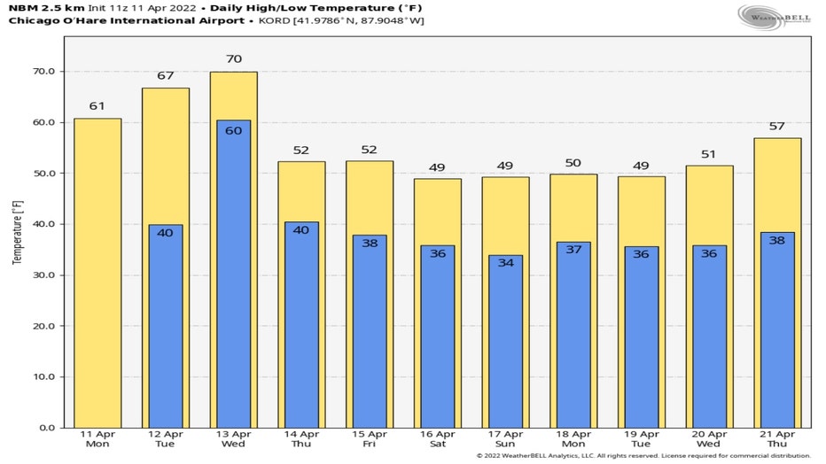
Our streak with highs of 60 degrees or more won't last long. We fall into the lower 50s for highs by Tuesday according to the National Blend Of Models forecast. We could then see seven straight days with temperatures below average.
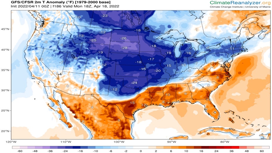
Temperature Anomaly Forecast For Monday Afternoon (ClimateReanalyzer.org)
Average highs for the middle of April are in the upper 50s to near 60 degrees. The GFS model temperature anomaly forecast shows just how far we will fall below average. The forecast for the middle of Monday afternoon has our temperatures dropping close to ten degrees below average. Some of us may fail to get above the 40s Saturday through Tuesday.
In other words, don't put away all your chilly weather gear just yet.