

Live updates: Rash of tornado outbreaks across Illinois, NW Indiana
CHICAGO - Parts of the Chicago area and northwest Indiana are under a Tornado Watch Tuesday evening as severe storms are expected to move in late this afternoon and continue into early Wednesday, bringing the potential for strong tornadoes, large hail and damaging winds.
Stay with FOX Chicago throughout the night for the latest real-time updates on severe weather passing through Chicagoland.
Live severe weather updates
8:30 p.m.: Tornado Warning for La Porte County
FOX Chicago Chief Meteorologist Emily Wahls is reporting that a Tornado Warning is now in effect for La Porte County, Indiana. At 8:25 p.m. CDT, a confirmed large and extremely dangerous tornado was spotted near North Judson, or 10 miles west of Knox, moving east at 20 mph. Take cover immediately if you are in the vicinity.
8:27 p.m.: Severe Thunderstorm Warning for LaSalle County
A Severe Thunderstorm Warning is in effect for parts of LaSalle and Livingston counties until 9:15 p.m., according to the National Weather Service.
8:15 p.m.: Flash Flood Warning in effect
The National Weather Service has issued a Flash Flood Warning for portions of LaSalle County until midnight.
8:12 p.m.: Heavy storm damage in Kankakee County
According to the Kankakee County Sheriff's Office says the confirmed tornado touched down south of Kankakee, near the Kankakee Fairgrounds, before it continued northeast and crossed the river into Aroma Park.
Extensive damage was reported in Aroma Park and their sheriff's office says it is still surveying the area for injuries and assessing the damage.
Residents and motorists are urged to limit travel in the area as much as possible due to treats and other debris, including downed power lines.
The 911 Center is also overwhelmed with emergency calls and residents are urged not to call for non-emergency related inquiries, according to authorities.
8 p.m.: Tornado Warning for LaPorte, Starke Counties; Severe Storm Warnings issued
A Tornado Warning has been issued for LaPorte and Starke Counties in Indiana until 8:30 p.m., according to the NWS.
Severe Thunderstorm Warning for Grundy County and Kendall County until 9 p.m.
7:42 p.m.: Tornado Warning issued for parts of Porter, Jasper Counties
A Tornado Warning has been issued for parts of Porter and Jasper Counties in Indiana until 8:45 p.m.
7:40 p.m.: City of Kankakee issues statement
The City of Kankakee issued a statement on social media Tuesday evening following severe weather.
"The southern part of the City Of Kankakee and the Kankakee county area has been hit severely from a high wind event. Please avoid all roadways south of town and heading into Aroma Park. Route 45/52 is closed from River Road to Exit 308 of Interstate 57 due to down power lines and storm damage and fires.The City is aware of down wires in several alleys and working to barricade those areas until service can occur. Additionally, several streets are flooded at the intersections. The City advises that all people remain in their homes and avoid all roadways in the City Of Kankakee until further notice. The City will continue to provide updates throughout the night."
7:30 p.m.: Large tornado in Newton County; Ground Stop continues at Chicago airports
The NWS says the large rain-wrapped tornado will likely track between the north side of Roselawn, Ind. and the small town of Thayer, Ind., in far northeastern Newton County.
Midway Airport's ground stop will be in effect until 9 p.m. and O'Hare airport's ground stop will continue until 8:30 p.m.
7:22 p.m.: Tornado Warning issued for multiple NW Indiana counties
Jasper, Newton and Lake County, Ind. are under a tornado warning until 8:15 p.m., according to NWS.
7:15 p.m.: Severe Storm Warnings issued for parts of NW Indiana
A Severe Thunderstorm Warning has been issued for Jasper County, Porter County and Lake County, Ind. until 8:30 p.m., according to the NWS.
7:10 p.m.: Large, dangerous tornado in Lake Village
A large and dangerous tornado is on the ground heading toward Lake Village, Ind., according to FOX Chicago Meteorologist Emily Wahls. Take shelter now!
The NWS has issued a Tornado Warning for the area until 7:30 p.m.
7:05 p.m.: Severe Thunderstorm Warnings extended
The Severe Thunderstorm Warning for Kankakee County continues until 7:15 p.m. with apple-sized hail, according to the NWS.
The Severe Storm Warning also continues for Lake and Newton, Ind. Counties until 8 p.m.
7 p.m.: Tornado Warning extended for Kankakee, issued for Newton/Lake Co., Ind.
The Tornado Warning issued for Kankakee County has been extended until 7:30 p.m. and issued for Newton/Lake Counties in Indiana, according to the NWS.
FOX Chicago Meteorologist Emily Wahls confirms there was a large and extremely dangerous tornado spotted over Hopkins Park, or near Momence, moving east at 25 mph.
6:53 p.m.: Severe storm warning issued for parts of NW Indiana
A Severe Thunderstorm Warning was issued for Lake County, Ind. and Newton County, Ind. until 8 pm, according to the National Weather Service.
6:40 p.m.: FOX Chicago Weather Photos
Click the link below for the latest viewer-submitted photos of Tuesday's severe weather from around the Chicago area.

Chicago weather: Photos show baseball-sized hail as strong storms sweep through Chicago area
Fox 32 viewers captured photos and video of Tuesday's storms across the Chicago area.
6:37 p.m.: Ground Stop at O'Hare Airport:
O'Hare Airport is under a ground stop until 7:15 p.m. CDT due to thunderstorms.
6:28 p.m.: Large Tornado reported in Kankakee County by NWS
The National Weather Service is reporting a large tornado on the ground headed for Aroma Park.
6:15 p.m.: Tornado Warning for Kankakee County
The National Weather Service has issued a Tornado Warning for Kankakee County until 7 p.m. CDT. This is a destructive storm containing softball-sized hail.
NWS said the area of strong rotation is toward the Aroma Park area, including the far south side of Kankakee, along with the Kankakee Airport. Residents are urged to take shelter!
6:05 p.m.: Kankakee County under Severe T-storm Warning
A severe thunderstorm warning has been issued for Kankakee County, including Kankakee, Bourbonnais and Bradley until 7 p.m. CDT. Apple-sized hail possible from this storm.
6:00 p.m.: Large hail reported
The National Weather Service says it's received reports of large hail, the size of golf balls to tennis balls, in the areas of Woodridge, Downers Grove, Darien and Westmont.
5:47 p.m.: Severe Thunderstorm Warning for Chicago area
The National Weather Service has issued a severe thunderstorm warning for Cook County, including Chicago, and DuPage County, until 6:45 p.m. CDT. Ping-pong ball-sized hail is possible, according to FOX Chicago meteorologist Mike Caplan.
5:43 p.m.: Midway Airport under Ground Stop
A ground stop has been issued for Midway Airport until 6:30 p.m. CDT due to severe weather in the area.
5:41 p.m.: Severe Thunderstorm Watch issued
A severe thunderstorm watch has been issued for all of northern Illinois, including the Chicago area and northwest Indiana, until midnight, according to the National Weather Service.
5:40 p.m.: Livington County Severe T-Storm Warning extended
The National Weather Service has extended a severe thunderstorm warning for parts of Livington County until 5:45 p.m. The storm is capable of baseball-sized hail.
5:22 p.m.: Kankakee and Iroquois counties under Severe T-Storm Warning
The National Weather Service has issued a severe thunderstorm warning for parts of Kankakee and Iroquois counties until 6:00 p.m. CDT. This storm will contain tennis ball-sized hail, according to the weather service.
5:10 p.m.: Severe T-Storm Warning extended
A severe thunderstorm warning for parts of Livingston County has been extended until 5:30 p.m. CDT, according to the NWS. This storm is capable of producing tennis ball-sized hail.
5:05 p.m.: Severe Thunderstorm Warning for Chicago area
Northern Will, southwest Cook and a tiny portion of southern DuPage County are now under a severe thunderstorm warning until 6 p.m. CDT. Large hail is a primary hazard.
4:50 p.m.: Tornado Warning for Livingston County
The National Weather Service has issued a Tornado Warning for Livingston County until 5:30 p.m. CDT. AT 4:47 p.m. a severe thunderstorm capable of producing a tornado was located near Pontiac, moving east at 30 mph. Those in the areas of Pontiac, Odell and Cullom are advised to seek shelter immediately.
4:37 p.m.: Large hail impacting multiple counties
Meteorologist Mike Caplan says a severe thunderstorm with large hail is impacting parts of Kendall and Grundy counties, and another storm is hitting Livingston County with large hail and damaging gusts. A Severe Thunderstorm Warning is in effect for those locations until 5:15 p.m. CDT.
If you get caught in a hail storm while driving, the National Weather Service says to pull off the road and point your vehicle into the wind, as your windshield is the strongest window. The NWS also advised motorists to avoid parking under overpasses as this could block the flow of traffic.
4:20 p.m.: Severe Thunderstorm Warning for LaSalle County
A Severe Thunderstorm Warning is in effect until 5 p.m. CDT for northwestern Livingston and south central LaSalle counties. At 4:14 p.m., a severe thunderstorm was located over Flanagan — about 14 miles west of Pontiac — and moving northeast at 35 mph. The storm is capable of producing ping pong ball-sized hail and wind gusts up to 60 mph.
4:00 p.m.: Tornado Watch Issued
A tornado watch has been issued for Kankakee, Grundy, LaSalle, Newton and Jasper counties in the greater Chicagoland area until 11 p.m. CT. Additional storms which can produce drenching downpours and very large hail may occur farther north anywhere in Chicagoland.
3:40 p.m.: Be Weather Ready!
Tuesday is the day to be weather ready! Download the FOX Chicago Weather app now for the latest on severe storms across Chicagoland this evening. You can also send your weather photos to FOX Chicago, right through the app, or by emailing wfldweatherphotos@fox.com.
3:32 p.m.: All hazards possible south of I-80, NWS says
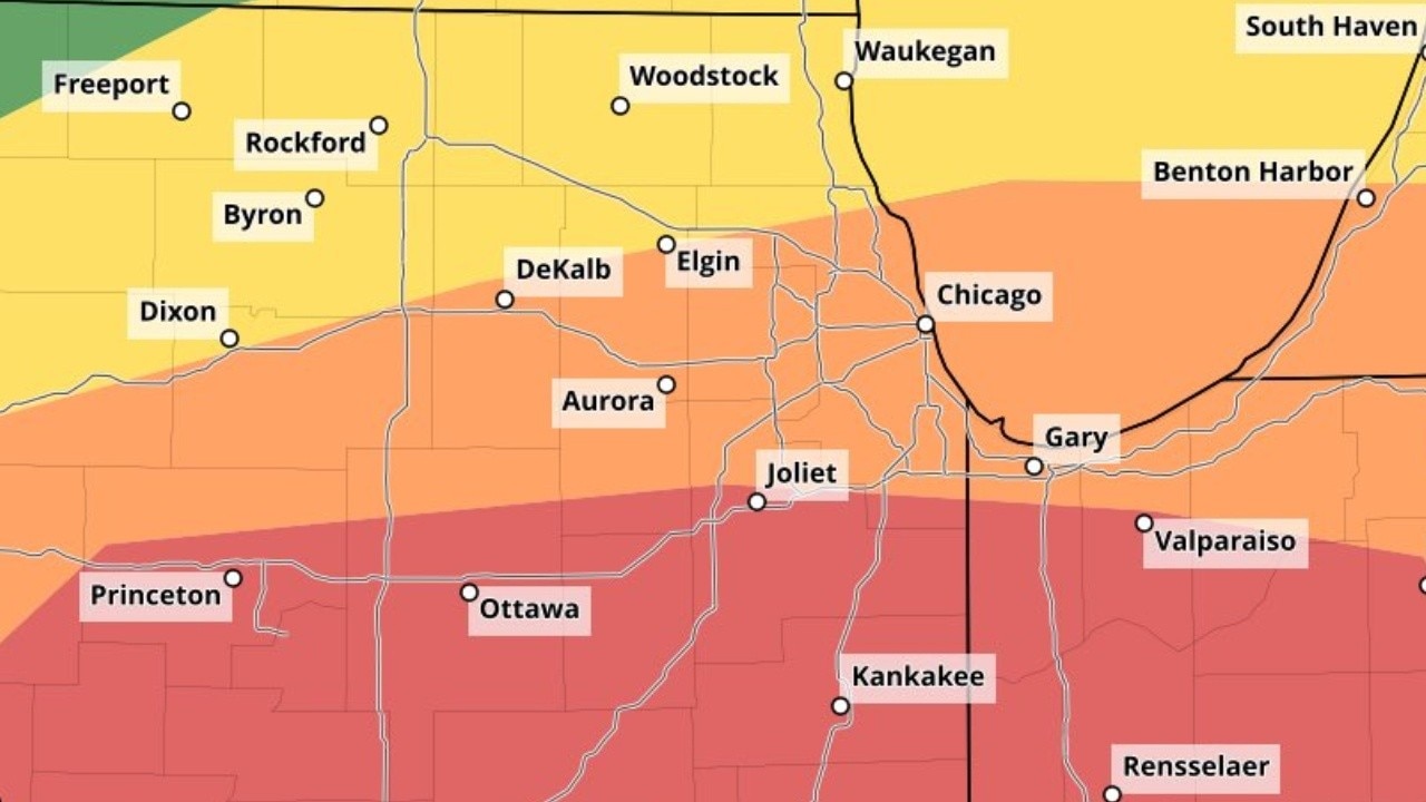
Severe storms are expected this evening, ending overnight — mainly southeast of I-80. North of I-80, the main threats are large hail and flooding, according to the National Weather Service in Chicago. Along and south of I-80, all severe weather hazards are possible, including strong tornadoes. Heavy rain falling over urban areas could lead to flooding, especially across the southern Chicago metro tonight.
3:20 p.m.: Large hail possible, according to Emily Wahls
If you own a vehicle and you live in the Chicago area, FOX Chicago chief meteorologist Emily Wahls says it'd be a good idea to find a covered space to park your car. Wahls said hail stones larger than 2-inches in diameter are possible in the strongest storms this evening and tonight.
1:40 p.m.: Mike Caplan's latest forecast
A powerful storm system is expected to bring severe weather to the Chicago area late this afternoon through the overnight hours, with threats including large hail, damaging winds, tornadoes and locally heavy rainfall. Mike Caplan's severe weather update.
11:50 a.m.: Severe weather risk upgraded
The Storm Prediction Center has placed southern portions of the Chicagoland area under a Moderate Risk for severe weather, which is Level 4 out of 5. That level is not issued often and signals a higher-end threat.
What we know:
The window for severe weather is roughly 3 p.m. Tuesday through 1 a.m. Wednesday.
Tornadoes, large hail possible as severe weather threat ramps up
Kaitlin Cody has your Chicago weather update!
Storms could produce hail 2 inches in diameter or larger, wind gusts greater than 70 mph and heavy rain that could lead to flooding. Tornadoes are also possible, including some that could be intense and stay on the ground for longer distances. They are most likely to spawn south of I-80.
The tornado risk map shows parts of the area in a 15% to 29% probability zone. For comparison, many severe weather days in the Chicago area carry a 2% to 5% tornado probability. Officials are urging residents to take today’s threat seriously.
In Chicago, temperatures are expected to fall into the 40s by the afternoon. Forecasters are closely watching a frontal boundary that will separate cooler air from warmer air to the south. Areas that remain in the warmer air will have a better chance of seeing tornadoes.
Residents are encouraged to have multiple ways to receive severe weather alerts and to know where they would take shelter if a tornado warning is issued.
What's next:
Conditions improve Wednesday, but it will turn colder with highs in the 40s. There is a chance rain could mix with snow, especially north of the city.
Thursday brings sunshine and highs in the upper 40s, though it is expected to become gusty Thursday night with another chance for rain. Friday will be partly sunny with highs around 50.
The weekend looks mostly cloudy with highs in the upper 40s to near 50. Rain is possible Saturday afternoon and night, and a rain-snow mix could develop Sunday.
Early next week starts mostly cloudy and much colder. Highs on Monday are expected to be in the upper 20s.
The Source: The information in this forecast came from FOX Chicago's Emily Wahls, Kaitlin Cody, and the Storm Prediction Center.